IMAGES TAKEN NEAR TO
Auburn Court, WALLSEND, NE28 0BL
Introduction
This page details the photographs taken nearby to Auburn Court, NE28 0BL by members of the Geograph project.
The Geograph project started in 2005 with the aim of publishing, organising and preserving representative images for every square kilometre of Great Britain, Ireland and the Isle of Man.

There are currently over 7.5m images from over14,400 individuals and you can help contribute to the project by visiting https://www.geograph.org.uk
Image Map (Loading...)


Getting Data...Please wait
Leaflet Map data © OpenStreetMap
Images are licensed for reuse under creativecommons.org/licenses/by-sa/2.0
Notes
- Clicking on the map will re-center to the selected point.
- The higher the marker number, the further away the image location is from the centre of the postcode.
Image Listing (30 Images Found)
Images are licensed for reuse under creativecommons.org/licenses/by-sa/2.0
Image
Details
Distance
1
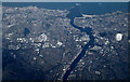
Tynemouth from the air
North Shields is on the left bank, South Shields on the right. Viewed from an Amsterdam bound flight from Glasgow.
Image: © Thomas Nugent
Taken: 2 Mar 2015
0.04 miles
2

Tynemouth from the air
North Shields is on the left bank, South Shields on the right. Viewed from an Amsterdam bound flight from Glasgow.
Image: © Thomas Nugent
Taken: 2 Mar 2015
0.04 miles
3
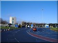
Tyne Tunnel toll booths.
The pay booths at the north entrance to the Tyne road tunnel. (Toll - £1 for a car, in December 2006).
Image: © Roger Cornfoot
Taken: 16 Dec 2006
0.04 miles
4
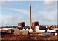
Howdon gas holders and former Cookson Matthey chimney
Looking towards Howdon from the South side of the river Tyne. The chimney was taken down in 2002.
Image: © Chris Bell
Taken: 22 Feb 1998
0.04 miles
5

Millennium Milepost, Howdon
On route 72 of the National Cycleway, west of the Tyne Tunnels.
Hopefully nobody is going to complain about this being posted - amazingly I once had a request to take down a similar picture.
Image: © Richard Webb
Taken: 1 Oct 2015
0.07 miles
9
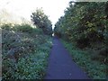
Cycle path
Route 72, using a railway trackbed. The railway is shown as operational on the 1976 1:50,000 Ordnance Survey map.
Image: © Richard Webb
Taken: 1 Oct 2015
0.10 miles
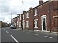
10
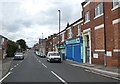
Station Road, Willington Quay
Junction of Station Road and Bewicke Road. Taken in 1991. Area of greenery visible in distance is now built over.
Image: © Clint Mann
Taken: Unknown
0.12 miles