IMAGES TAKEN NEAR TO
Stanton Road, NEWCASTLE UPON TYNE, NE27 0PW
Introduction
This page details the photographs taken nearby to Stanton Road, NE27 0PW by members of the Geograph project.
The Geograph project started in 2005 with the aim of publishing, organising and preserving representative images for every square kilometre of Great Britain, Ireland and the Isle of Man.

There are currently over 7.5m images from over14,400 individuals and you can help contribute to the project by visiting https://www.geograph.org.uk
Image Map
Images are licensed for reuse under creativecommons.org/licenses/by-sa/2.0
Notes
- Clicking on the map will re-center to the selected point.
- The higher the marker number, the further away the image location is from the centre of the postcode.
Image Listing (14 Images Found)
Images are licensed for reuse under creativecommons.org/licenses/by-sa/2.0
Image
Details
Distance
1
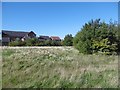
Open space, Shiremoor
Houses off New York Road seen across open land from the former railway.
Image: © Richard Webb
Taken: 1 Oct 2015
0.15 miles
2
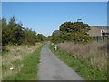
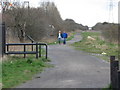
Cramlington Colliery Railway, Shiremoor
The railway, shown as operational on 1970s maps, is now a cycle path.
Image: © Richard Webb
Taken: 1 Oct 2015
0.16 miles


6
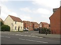
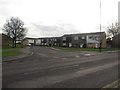
Edgefield, Shiremoor
A modern housing development on the edge of Shiremoor.
Image: © Graham Robson
Taken: 1 May 2017
0.19 miles
7
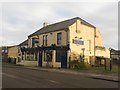
The Blue Bell, Shiremoor
A public house on Earsdon Road in Shiremoor.
Image: © Graham Robson
Taken: 10 Dec 2016
0.21 miles
8
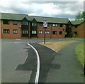
Lesbury Avenue, Shiremoor
Lesbury Avenue, a quiet residential street off Earsdon Road in Shiremoor.
Image: © Graham Robson
Taken: 10 Dec 2016
0.22 miles
10
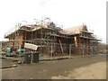
Construction site, Earsdon Road, Shiremoor
A large building under construction on Earsdon Road in Shiremoor.
Image: © Graham Robson
Taken: 10 Dec 2016
0.23 miles