IMAGES TAKEN NEAR TO
Murton Village, NEWCASTLE UPON TYNE, NE27 0LX
Introduction
This page details the photographs taken nearby to NE27 0LX by members of the Geograph project.
The Geograph project started in 2005 with the aim of publishing, organising and preserving representative images for every square kilometre of Great Britain, Ireland and the Isle of Man.

There are currently over 7.5m images from over14,400 individuals and you can help contribute to the project by visiting https://www.geograph.org.uk
Image Map (Loading...)


Getting Data...Please wait
Leaflet Map data © OpenStreetMap
Images are licensed for reuse under creativecommons.org/licenses/by-sa/2.0
Notes
- Clicking on the map will re-center to the selected point.
- The higher the marker number, the further away the image location is from the centre of the postcode.
Image Listing (14 Images Found)
Images are licensed for reuse under creativecommons.org/licenses/by-sa/2.0
Image
Details
Distance
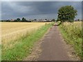
2
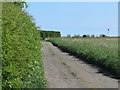
Access Track, Murton Steads Farm near Murton
The track is the only means of vehicular access to Murton Steads Farm. The structures in the far distance belong to North Tyneside General Hospital on Rake Lane. For a selection of detailed free to download walking routes in the area visit www.northtynesidewalks.co.uk
Image: © Geoff Holland
Taken: 1 May 2020
0.06 miles
5
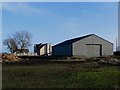
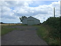
Murton Steads
Murton Steads, consisting of a single modern house and large farm shed.
Image: © Graham Robson
Taken: 24 Feb 2018
0.07 miles
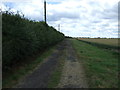
6
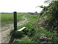
Public Footpath near Murton
This short footpath links the public bridleway from West Monkseaton with Murton Lane. The post and step are evidence of the former existence of a
gate and stile. For a selection of detailed free to download walking routes in the area visit www.northtynesidewalks.co.uk
Image: © Geoff Holland
Taken: 19 Apr 2020
0.10 miles
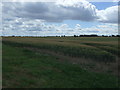
7
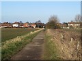
Bridleway, West Monkseaton
A public bridleway crossing farmland between West Monkseaton and Murton.
Image: © Graham Robson
Taken: 24 Feb 2018
0.12 miles
9
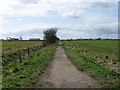
Path from Murton to West Monkseaton
Murton Gap is an area of approximately 400 hectares of farmland surrounding Murton village. The area is almost entirely surrounded by built-up areas of North Tyneside. Plans to build up to 3,000 houses on this area of green belt are being vigorously opposed.
Image: © Oliver Dixon
Taken: 5 Aug 2016
0.19 miles
10
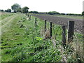
Old Boundary Fence near Murton
This old fence runs alongside a public footpath leading to Murton Lane. For a selection of detailed free to download walking routes in the area visit www.northtynesidewalks.co.uk
Image: © Geoff Holland
Taken: 22 Apr 2020
0.20 miles