IMAGES TAKEN NEAR TO
Well Lane, NEWCASTLE UPON TYNE, NE27 0LU
Introduction
This page details the photographs taken nearby to Well Lane, NE27 0LU by members of the Geograph project.
The Geograph project started in 2005 with the aim of publishing, organising and preserving representative images for every square kilometre of Great Britain, Ireland and the Isle of Man.

There are currently over 7.5m images from over14,400 individuals and you can help contribute to the project by visiting https://www.geograph.org.uk
Image Map (39 Images)


Getting Data...Please wait
Leaflet Map data © OpenStreetMap
Images are licensed for reuse under creativecommons.org/licenses/by-sa/2.0
Notes
- Clicking on the map will re-center to the selected point.
- The higher the marker number, the further away the image location is from the centre of the postcode.
Image Listing (39 Images Found)
Images are licensed for reuse under creativecommons.org/licenses/by-sa/2.0
Image
Details
Distance
1

Sign on Murton Lane, Murton
This public footpath appears to be pointing slightly in the wrong direction although it is clear, on the ground, where the narrow footpath heads as it squeezes between two adjacent properties. For a selection of detailed free to download walking routes in the area visit www.northtynesidewalks.co.uk
Image: © Geoff Holland
Taken: 19 Apr 2020
0.02 miles
2
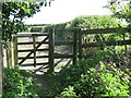
Kissing Gate at North Farm, Murton
This gate, which lies on the course of the public footpath referred to at https://www.geograph.org.uk/photo/6448046, leads to and thence across a compound at the rear of North Farm. For a selection of detailed free to download walking routes in the area visit www.northtynesidewalks.co.uk
Image: © Geoff Holland
Taken: 19 Apr 2020
0.04 miles
3
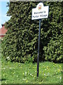
Welcome Sign, Murton
This sign, which bears the crest of North Tyneside Council, stands on a sharp bend at the western entrance to the village. For a selection of detailed free to dwownload walking routes in the area visit www.northtynesidewalks.co.uk
Image: © Geoff Holland
Taken: 1 May 2020
0.04 miles
5
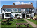
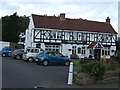
The Robin Hood Inn, Murton
The first mention of an inn at this location, on a map of the area, appeared on the 1920 published Ordnance Survey Six-Inch map, although it did not refer to any specific name. The attractive building sits comfortably in this small village. For a selection of detailed free to download walking routes in the area visit www.northtynesidewalks.co.uk
Image: © Geoff Holland
Taken: 19 Apr 2020
0.05 miles
6
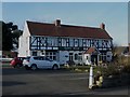
The Robin Hood, Murton
The only pub in the small village of Murton which is close to but separated from the edge of the urban sprawl at New York.
Image: © Graham Robson
Taken: 24 Feb 2018
0.05 miles
7
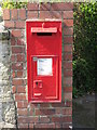
Wall Mounted Victorian Letter Box, Murton
Reference to this fine Victorian letter box first appeared on the 1920-published Ordnance Survey Six-Inch map of the area under the abbreviation of 'L.B.'. For a selection of detailed free to download walking routes in the area visit www.northtynesidewalks.co.uk
Image: © Geoff Holland
Taken: 19 Apr 2020
0.05 miles
8
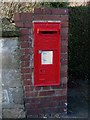
Postbox, Murton
A Victorian wall box in a brick column on Murton Lane in the middle of the village. The location of the box can be seen in Image
Image: © Graham Robson
Taken: 24 Feb 2018
0.06 miles
9
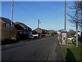
Murton Lane, Murton
The main street in the small village of Murton. A telephone box and post box are on either side of the road.
Image: © Graham Robson
Taken: 24 Feb 2018
0.06 miles
10

Public telephone box, Murton
A public telephone box in Murton which still retains its telephone. It is also carrying a large advertisement for a large popular food chain.
Image: © Graham Robson
Taken: 24 Feb 2018
0.06 miles