IMAGES TAKEN NEAR TO
Park Avenue, NEWCASTLE UPON TYNE, NE27 0LG
Introduction
This page details the photographs taken nearby to Park Avenue, NE27 0LG by members of the Geograph project.
The Geograph project started in 2005 with the aim of publishing, organising and preserving representative images for every square kilometre of Great Britain, Ireland and the Isle of Man.

There are currently over 7.5m images from over14,400 individuals and you can help contribute to the project by visiting https://www.geograph.org.uk
Image Map (12 Images)


Getting Data...Please wait
Leaflet Map data © OpenStreetMap
Images are licensed for reuse under creativecommons.org/licenses/by-sa/2.0
Notes
- Clicking on the map will re-center to the selected point.
- The higher the marker number, the further away the image location is from the centre of the postcode.
Image Listing (12 Images Found)
Images are licensed for reuse under creativecommons.org/licenses/by-sa/2.0
Image
Details
Distance
1
Path, Shiremoor
This roughly surfaced path, which is not shown on the Ordnance Survey map of the area, leads from Shiremoor to the South Wellfield Pedestrian Crossing shown at https://www.geograph.org.uk/photo/6448948 and appears to be well utilised. For a selection of detailed free to download walking routes in the area visit www.northtynesidewalks.co.uk
Image: © Geoff Holland
Taken: 22 Apr 2020
0.09 miles
2
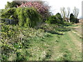
Footpath, Shiremoor
Whilst not shown on the Ordnance Survey map of the area as a public footpath, this path, which runs between Murton village and Shiremoor following field boundaries, is a well-worn, regularly utilised route. For a selection of detailed free to download walking routes in the area visit www.northtynesidewalks.co.uk
Image: © Geoff Holland
Taken: 22 Apr 2020
0.10 miles
3
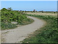
Footpath crossing farmland
A public crossing the farmland separating Shiremoor and South Wellfield.
Image: © Graham Robson
Taken: 24 Nov 2018
0.15 miles
4
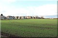
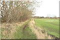
Farmland on the edge of Shiremoor
An arable field containing an autumn sown cereal crop on the edge of Shiremoor.
Image: © Graham Robson
Taken: 24 Nov 2018
0.17 miles
5
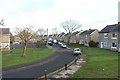
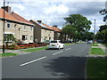
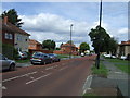
Grange Avenue, Shiremoor
A residential street in Shiremoor with semi detached houses on either side of the road.
Image: © Graham Robson
Taken: 24 Nov 2018
0.20 miles
6
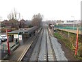
Shiremoor Metro Station
Looking down from a road bridge crossing the tracks to the station at Shiremoor on the Tyne and Wear Metro line through North Tyneside.
Image: © Graham Robson
Taken: 10 Dec 2016
0.21 miles
7
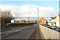
Park Lane, Shiremoor
Looking north along Park Lane in Shiremoor.
Image: © Graham Robson
Taken: 24 Nov 2018
0.22 miles
9
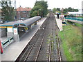
Shiremoor Metro station, Tyne & Wear
Opened in 1980 by the Tyne & Wear Metro on the North Tyneside loop line from Newcastle to Tynemouth.
View west towards Backworth and Newcastle.
Image: © Nigel Thompson
Taken: 17 Sep 2010
0.22 miles