IMAGES TAKEN NEAR TO
Sandon Close, NEWCASTLE UPON TYNE, NE27 0JX
Introduction
This page details the photographs taken nearby to Sandon Close, NE27 0JX by members of the Geograph project.
The Geograph project started in 2005 with the aim of publishing, organising and preserving representative images for every square kilometre of Great Britain, Ireland and the Isle of Man.

There are currently over 7.5m images from over14,400 individuals and you can help contribute to the project by visiting https://www.geograph.org.uk
Image Map (Loading...)


Getting Data...Please wait
Leaflet Map data © OpenStreetMap
Images are licensed for reuse under creativecommons.org/licenses/by-sa/2.0
Notes
- Clicking on the map will re-center to the selected point.
- The higher the marker number, the further away the image location is from the centre of the postcode.
Image Listing (65 Images Found)
Images are licensed for reuse under creativecommons.org/licenses/by-sa/2.0
Image
Details
Distance
2
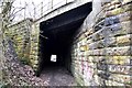
North entrance to bridge carrying mineral line over the old rope waggonway
Image: © Ron Dixon
Taken: 20 Jan 2017
0.09 miles
3
Bridge carrying mineral line over footpath
The footpath was originally the route of an old rope waggonway leading coal from the local mine down to the Tyne.
Image: © Ron Dixon
Taken: 20 Jan 2017
0.09 miles
4
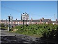
Shrewsbury Drive, Backworth
A residential street in the east end of Backworth.
Image: © Graham Robson
Taken: 10 Dec 2016
0.10 miles
5
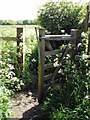
Open Gate
Although no livestock in this field, the gate should be kept closed
Image: © Christine Westerback
Taken: 9 Jun 2012
0.10 miles
6
Site of Holywell Goods Station
Holywell Goods station was opened by the Blyth and Tyne Railway in 1864 following the closure of a passenger station to the north of the crossing - see Image
Details of Holywell/Backworth station is on the Disused Stations website http://www.disused-stations.org.uk/b/backworth_first/index.shtml
Image: © Anthony Foster
Taken: 18 Mar 2015
0.10 miles
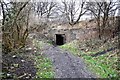
7
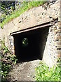
Scary Tunnel
A rather dark and scary tunnel underneath Backworth Mineral Line
Image: © Christine Westerback
Taken: 9 Jun 2012
0.10 miles
8
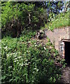
Beside the Tunnel
Which runs under the Backworth Mineral Line
Image: © Christine Westerback
Taken: 9 Jun 2012
0.10 miles
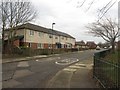
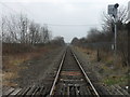
10
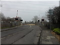
Holywell Level Crossing
This freight line serving Bedlington and Ashington was opened by the Blyth, Seghill and Percy Main Railway. Holywell station (later re-named Backworth) was sited to the north of the crossing - see Image After its closure in 1864 a goods station named Holywell was re-sited to the south of the crossing - see Image]: It closed on 7 June 1965. Details of Holywell/Backworth station is on the Disused Stations website http://www.disused-stations.org.uk/b/backworth_first/index.shtml
Image: © Anthony Foster
Taken: 18 Mar 2015
0.11 miles