IMAGES TAKEN NEAR TO
Whitley Road, NEWCASTLE UPON TYNE, NE27 0DA
Introduction
This page details the photographs taken nearby to Whitley Road, NE27 0DA by members of the Geograph project.
The Geograph project started in 2005 with the aim of publishing, organising and preserving representative images for every square kilometre of Great Britain, Ireland and the Isle of Man.

There are currently over 7.5m images from over14,400 individuals and you can help contribute to the project by visiting https://www.geograph.org.uk
Image Map (Loading...)


Getting Data...Please wait
Leaflet Map data © OpenStreetMap
Images are licensed for reuse under creativecommons.org/licenses/by-sa/2.0
Notes
- Clicking on the map will re-center to the selected point.
- The higher the marker number, the further away the image location is from the centre of the postcode.
Image Listing (13 Images Found)
Images are licensed for reuse under creativecommons.org/licenses/by-sa/2.0
Image
Details
Distance
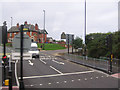
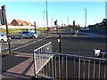
2
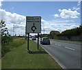
Cycle paths on the Holystone roundabout
The Holystone roundabout is a major traffic interchange. Three major and two minor roads converge on the roundabout, together with slip roads up to and down from the A19 which passes overhead. Unusually, cycle traffic across the roundabout has been implemented by constructing cycleways inside the roundabout; access is assured by a phase on the various traffic signals.
Image: © Oliver Dixon
Taken: 4 Dec 2013
0.06 miles
3
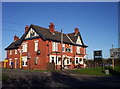
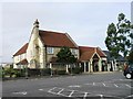
The Holystone
This public house is named after the area in which it stands.
Image: © Weston Beggard
Taken: 13 Nov 2005
0.07 miles
4
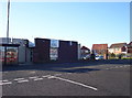
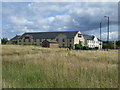
Allotment Social Club
Whilst dying out in inner-city areas, CIU clubs like this continue to thrive in smaller, outlying communities.
Image: © Weston Beggard
Taken: 13 Nov 2005
0.07 miles

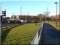
9
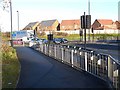
Cycle path on the Holystone roundabout
The Holystone roundabout is a major traffic interchange. Three major and two minor roads converge on the roundabout, together with slip roads up to and down from the A19 which passes overhead. Unusually, cycle traffic across the roundabout has been implemented by constructing cycleways inside the roundabout; access is enabled by a phase on the various traffic signals.
Image: © Oliver Dixon
Taken: 4 Dec 2013
0.17 miles
10
Crossing onto the Holystone roundabout
The Holystone roundabout is a major traffic interchange. Three major and two minor roads converge on the roundabout, together with slip roads up to and down from the A19 which passes overhead. Unusually, cycle traffic across the roundabout has been implemented by constructing cycleways inside the roundabout; access is enabled by a phase on the various traffic signals.
Image: © Oliver Dixon
Taken: 4 Dec 2013
0.18 miles