IMAGES TAKEN NEAR TO
Holystone, NEWCASTLE UPON TYNE, NE27 0BZ
Introduction
This page details the photographs taken nearby to NE27 0BZ by members of the Geograph project.
The Geograph project started in 2005 with the aim of publishing, organising and preserving representative images for every square kilometre of Great Britain, Ireland and the Isle of Man.

There are currently over 7.5m images from over14,400 individuals and you can help contribute to the project by visiting https://www.geograph.org.uk
Image Map (Loading...)


Getting Data...Please wait
Leaflet Map data © OpenStreetMap
Images are licensed for reuse under creativecommons.org/licenses/by-sa/2.0
Notes
- Clicking on the map will re-center to the selected point.
- The higher the marker number, the further away the image location is from the centre of the postcode.
Image Listing (5 Images Found)
Images are licensed for reuse under creativecommons.org/licenses/by-sa/2.0
Image
Details
Distance
5
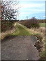
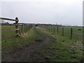
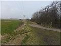
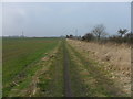
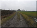
Footpath near Shiremoor
Possibly one of the many waggonways linking former coalmines in North Tyneside with the coal staithes on the Tyne. An underpass under the A19 can be seen in the distance.
Image: © Oliver Dixon
Taken: 23 Feb 2012
0.24 miles