IMAGES TAKEN NEAR TO
Heathfield, NEWCASTLE UPON TYNE, NE27 0BP
Introduction
This page details the photographs taken nearby to Heathfield, NE27 0BP by members of the Geograph project.
The Geograph project started in 2005 with the aim of publishing, organising and preserving representative images for every square kilometre of Great Britain, Ireland and the Isle of Man.

There are currently over 7.5m images from over14,400 individuals and you can help contribute to the project by visiting https://www.geograph.org.uk
Image Map (Loading...)


Getting Data...Please wait
Leaflet Map data © OpenStreetMap
Images are licensed for reuse under creativecommons.org/licenses/by-sa/2.0
Notes
- Clicking on the map will re-center to the selected point.
- The higher the marker number, the further away the image location is from the centre of the postcode.
Image Listing (40 Images Found)
Images are licensed for reuse under creativecommons.org/licenses/by-sa/2.0
Image
Details
Distance
1
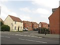
Edgefield, Shiremoor
A modern housing development on the edge of Shiremoor.
Image: © Graham Robson
Taken: 1 May 2017
0.05 miles
2
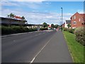
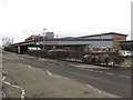
Along Earsdon Road, Shiremoor
Sainsbury superstore on the left
Image: © David Clark
Taken: 28 Jul 2012
0.05 miles

5
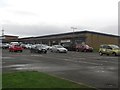
Retail Park, Northumberland Park
A small retail park at Northumberland Park with shops serving the needs of the local population.
Image: © Graham Robson
Taken: 10 Dec 2016
0.07 miles
6
Sainsbury's supermarket, Northumberland Park
A Sainsbury's supermarket in Northumberland Park, adjacent to Northumberland Park Metro Station.
Image: © Graham Robson
Taken: 10 Dec 2016
0.08 miles
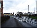
7
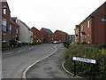
Cloverfield
A road on a new Development
Image: © Alex McGregor
Taken: 7 Apr 2010
0.09 miles
8
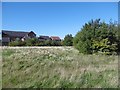
Open space, Shiremoor
Houses off New York Road seen across open land from the former railway.
Image: © Richard Webb
Taken: 1 Oct 2015
0.10 miles
9
Backworth railway station (site), Tyne & Wear
Opened in 1871 by the Blyth & Tyne Railway on what later became the North Tyneside loop line from Newcastle to Tynemouth, this station closed in 1977.
View north east towards Shiremoor and Tynemouth. Taken from the new platforms of Northumberland Park Metro station, the original platforms were on either side of the tracks and ran to the overbridge. A stone-built building was on the right hand platform, and a wooden building was provided at street level.
Image: © Nigel Thompson
Taken: 17 Sep 2010
0.11 miles
10
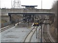
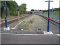
Metro Line, Northumberland Park
The Metro Line at Northumberland Park. The station is a relatively recent addition to the network. A Network Rail heavy rail line passes to the right of the metro train standing at the platform.
Image: © Graham Robson
Taken: 10 Dec 2016
0.11 miles