IMAGES TAKEN NEAR TO
Castle Square, NEWCASTLE UPON TYNE, NE27 0BA
Introduction
This page details the photographs taken nearby to Castle Square, NE27 0BA by members of the Geograph project.
The Geograph project started in 2005 with the aim of publishing, organising and preserving representative images for every square kilometre of Great Britain, Ireland and the Isle of Man.

There are currently over 7.5m images from over14,400 individuals and you can help contribute to the project by visiting https://www.geograph.org.uk
Image Map (Loading...)


Getting Data...Please wait
Leaflet Map data © OpenStreetMap
Images are licensed for reuse under creativecommons.org/licenses/by-sa/2.0
Notes
- Clicking on the map will re-center to the selected point.
- The higher the marker number, the further away the image location is from the centre of the postcode.
Image Listing (18 Images Found)
Images are licensed for reuse under creativecommons.org/licenses/by-sa/2.0
Image
Details
Distance
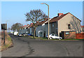
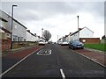
1
Killingworth Lane, Backworth
The B1317 has been realigned leaving this part of Killingworth Lane as a quiet residential street.
Image: © Richard Webb
Taken: 1 Oct 2015
0.04 miles

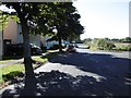
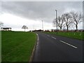
3
Killingworth Lane
Near the village of Backworth.
Image: © Chris Tweedy
Taken: 24 Jan 2006
0.12 miles
4
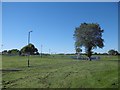
Play park, Backworth
A play park in an open area at the west end of Backworth.
Image: © Graham Robson
Taken: 10 Dec 2016
0.14 miles
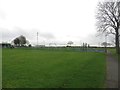
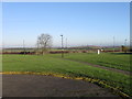
5
Open space, Backworth
On the western edge of the village.
Image: © Richard Webb
Taken: 1 Oct 2015
0.15 miles
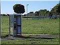
9
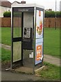
Public telephone box, Backworth
A public telephone box which has seen better days located near Killingworth Avenue, Backworth.
Image: © Graham Robson
Taken: 10 Dec 2016
0.16 miles