IMAGES TAKEN NEAR TO
Simonside Close, WHITLEY BAY, NE26 4BW
Introduction
This page details the photographs taken nearby to Simonside Close, NE26 4BW by members of the Geograph project.
The Geograph project started in 2005 with the aim of publishing, organising and preserving representative images for every square kilometre of Great Britain, Ireland and the Isle of Man.

There are currently over 7.5m images from over14,400 individuals and you can help contribute to the project by visiting https://www.geograph.org.uk
Image Map
Images are licensed for reuse under creativecommons.org/licenses/by-sa/2.0
Notes
- Clicking on the map will re-center to the selected point.
- The higher the marker number, the further away the image location is from the centre of the postcode.
Image Listing (57 Images Found)
Images are licensed for reuse under creativecommons.org/licenses/by-sa/2.0
Image
Details
Distance
2

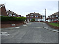
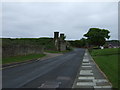
Simonside Close at Hartley
Housing estate at Hartley, south of Seaton Sluice.
Image: © Robert Graham
Taken: 3 Oct 2012
0.05 miles
3

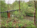
Pipe Bridge, Holywell Dene
This is one of two pipe bridges that cross the Seaton Burn in this part of Holywell Dene. Fairly well-screened by the surrounding woodland, this pipe line carries sewage sludge. For a selection of detailed free to download walking routes in the area visit www.northtynesidewalks.co.uk
Image: © Geoff Holland
Taken: 6 May 2020
0.09 miles
4
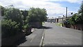
Dereham Road, Hartley
Residential area south of Seaton Sluice.
Image: © Richard Webb
Taken: 31 Jul 2012
0.09 miles
5
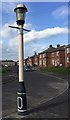
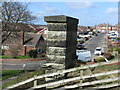
Joseph Webb Sewer Gas Destructor Lamp
This was no ordinary gas lamp, this was Victorian engineering at its finest, and recycling well ahead of its time. It was designed to draw foul gases from the sewers and burn them off, thereby not only eradicating the smell, but also providing light. Very few of these lamps remain, this is one of five in Seaton Valley. Sadly it lacks its finial crest. See also
Image Image
https://www.thenorthernecho.co.uk/history/3558291.raising-stink/
https://www.xenophon.org.uk/webbsewerlamp.html
Image: © Leanmeanmo
Taken: 4 Mar 2020
0.11 miles
9
Parapet of old railway bridge, Hartley
The Collywell Bay Branch Line was constructed in the early part of the 20th century to serve a station at Collywell Bay. Although the line was built, the Collywell Bay Station did not open and the branch line was abandoned in 1931. It was intended that the line would promote Seaton Sluice as a resort. This parapet is one of two remaining parapets of the now demolished bridge over Hartley Road which lies half a mile south of the former Collywell Bay Station. For a selection of detailed free to download walking routes in the area visit www.northtynesidewalks.co.uk
Image: © Geoff Holland
Taken: 12 Mar 2020
0.13 miles
10
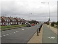
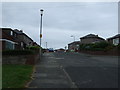
Beresford Road, Seaton Sluice
Looking north along the main road through Seaton Sluice. A cycle lane follows the side of the road closest to the sea.
Image: © Graham Robson
Taken: 20 Feb 2016
0.13 miles