IMAGES TAKEN NEAR TO
Marine Avenue, WHITLEY BAY, NE26 3LS
Introduction
This page details the photographs taken nearby to Marine Avenue, NE26 3LS by members of the Geograph project.
The Geograph project started in 2005 with the aim of publishing, organising and preserving representative images for every square kilometre of Great Britain, Ireland and the Isle of Man.

There are currently over 7.5m images from over14,400 individuals and you can help contribute to the project by visiting https://www.geograph.org.uk
Image Map
Images are licensed for reuse under creativecommons.org/licenses/by-sa/2.0
Notes
- Clicking on the map will re-center to the selected point.
- The higher the marker number, the further away the image location is from the centre of the postcode.
Image Listing (42 Images Found)
Images are licensed for reuse under creativecommons.org/licenses/by-sa/2.0
Image
Details
Distance
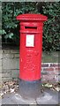
2
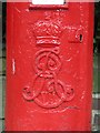
Edward VII postbox, Marine Avenue - royal cipher
See Image
Image: © Mike Quinn
Taken: 24 Sep 2017
0.06 miles
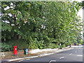
3
Edward VII postbox, Marine Avenue
Image: © Mike Quinn
Taken: 24 Sep 2017
0.06 miles
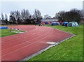
4
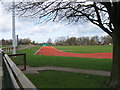
Running track, Churchill Playing Field
Image: © Alex McGregor
Taken: 8 Apr 2010
0.06 miles
6
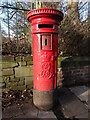
Post Box, Marine Avenue, Whitley Bay
This post box dates from the reign of Edward VII (1901-1910) and has seen better days. Since Mike Quinn passed this way in 2017 https://www.geograph.org.uk/photo/5550879 the collection plate has been removed although the box still appears to be in use. The earliest Edwardian boxes (1901-1904) were modified from the last Victorian boxes but midway through his reign the elaborate scroll cipher, as seen here, began to appear on the post boxes. For a selection of detailed free to download walking routes in the area visit www.northtynesidewalks.co.uk
Image: © Geoff Holland
Taken: 18 Jan 2021
0.06 miles
7
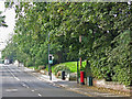
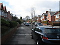
Marine Avenue
Shows the location of Image
The road rises to the left to cross over the metro lines just north of Monkseaton station - see http://www.geograph.org.uk/search.php?i=77327148 .
Image: © Mike Quinn
Taken: 24 Sep 2017
0.07 miles
8
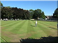
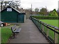
Bowling Green, Souter Park
This is one of four bowling greens situated in Souter Park, a lively suburban park which straddles Marine Avenue. This particular green is home to Souter Park Bowling Club with the adjacent green, behind the photographer, home to Forth Bowling Club.
Image: © Geoff Holland
Taken: 1 Sep 2022
0.09 miles