IMAGES TAKEN NEAR TO
Holywell Avenue, WHITLEY BAY, NE26 3AG
Introduction
This page details the photographs taken nearby to Holywell Avenue, NE26 3AG by members of the Geograph project.
The Geograph project started in 2005 with the aim of publishing, organising and preserving representative images for every square kilometre of Great Britain, Ireland and the Isle of Man.

There are currently over 7.5m images from over14,400 individuals and you can help contribute to the project by visiting https://www.geograph.org.uk
Image Map
Images are licensed for reuse under creativecommons.org/licenses/by-sa/2.0
Notes
- Clicking on the map will re-center to the selected point.
- The higher the marker number, the further away the image location is from the centre of the postcode.
Image Listing (13 Images Found)
Images are licensed for reuse under creativecommons.org/licenses/by-sa/2.0
Image
Details
Distance
1
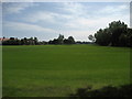
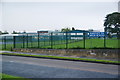
Playing Fields off Monkseaton Drive
Playing Fields attached to Whitley Bay High School.
Image: © Chris Heaton
Taken: 23 Jul 2008
0.04 miles
2
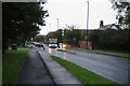
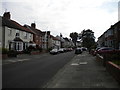
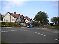
Monkseaton Drive, Whitley Bay
The bus is waiting to turn into Woodburn Drive. The wet weather makes it seem darker than it is.
Image: © Bill Boaden
Taken: 16 Sep 2011
0.06 miles
3

Subway under Monkseaton Drive
This interesting concrete structure allows the Waggonways Cycle Track under Monkseaton Drive near Whitley Bay High School.
Image: © Chris Heaton
Taken: 23 Jul 2008
0.11 miles
4

Underpass on the Monkseaton Waggonway
The Monkseaton Waggonway is one of the many old waggonways in North Tyneside which have been converted into cycle tracks. Here it passes under Monkseaton Drive (A1148). See also Image
Image: © Oliver Dixon
Taken: 2 Mar 2010
0.11 miles

6

Underpass under Monkseaton Drive
An underpass provides an easy means for pedestrians and other users following this bridleway to cross Monkseaton Drive.
Image: © Graham Robson
Taken: 29 Aug 2016
0.13 miles
8
North end of Swinbourne Gardens, Monkseaton
Where it meets Davison Avenue.
Image: © Richard Vince
Taken: 22 Jun 2019
0.19 miles
9
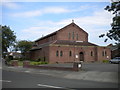
Church of St Mary the Virgin, Monkseaton
Seen from Swinbourne Gardens.
Image: © Richard Vince
Taken: 22 Jun 2019
0.20 miles