IMAGES TAKEN NEAR TO
Windsor Crescent, WHITLEY BAY, NE26 2NT
Introduction
This page details the photographs taken nearby to Windsor Crescent, NE26 2NT by members of the Geograph project.
The Geograph project started in 2005 with the aim of publishing, organising and preserving representative images for every square kilometre of Great Britain, Ireland and the Isle of Man.

There are currently over 7.5m images from over14,400 individuals and you can help contribute to the project by visiting https://www.geograph.org.uk
Image Map (Loading...)


Getting Data...Please wait
Leaflet Map data © OpenStreetMap
Images are licensed for reuse under creativecommons.org/licenses/by-sa/2.0
Notes
- Clicking on the map will re-center to the selected point.
- The higher the marker number, the further away the image location is from the centre of the postcode.
Image Listing (110 Images Found)
Images are licensed for reuse under creativecommons.org/licenses/by-sa/2.0
Image
Details
Distance
1
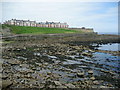
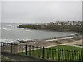
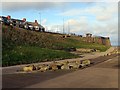
View from Brown's Bay
Looking north towards Whitley Bay.
Image: © Chris Heaton
Taken: 23 Jul 2008
0.01 miles
2
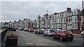
Windsor Crescent, Whitley Bay
Houses with elevated sea views. The traffic queue was due to the dreaded 4 way temporary traffic lights at a set of roadworks. Bikes were immune thanks to the Sustrans route along the promenade.
Image: © Richard Webb
Taken: 31 Jul 2012
0.01 miles
3
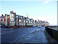
Windsor Crescent, Whitley Bay
Windsor Avenue is the junction on the left.
Image: © Andrew Curtis
Taken: 26 Dec 2009
0.03 miles
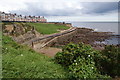
4
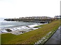
Promenade at Brown's Bay, Whitley Bay
View towards Brown's Point and the terrace on South Cliff Image
The Point features a Radio Telegraph Station, originally housed in a wooden shed built in 1906-7, used experimentally to send and receive messages from Denmark. The station operated with new buildings and aerials during both World Wars and eventually decommissioned in 1999.
Tyne and Wear HER (5519): http://www.twsitelines.info/siteline.nsf/8f71f680ce308c9a802573a80061c133/14393dd09c8d9a22802576af003e749d
Image: © Andrew Curtis
Taken: 26 Dec 2009
0.04 miles
6
Windsor Crescent overlooking Brown's Bay
Image: © Bill Boaden
Taken: 17 Sep 2011
0.04 miles
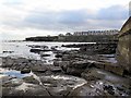
9
Promenade at Brown's Bay below Windsor Crescent
Image: © Andrew Curtis
Taken: 20 Nov 2015
0.05 miles
10
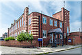
The Rockcliffe First School on Grafton Road, Whitley Bay
The Rockcliffe first school in Whitley Bay. This first school / nursery is located on Grafton Road in the seaside town.
The postcode of this location is Bay NE26 2NR
Image: © Garry Cornes
Taken: 3 Aug 2019
0.05 miles