IMAGES TAKEN NEAR TO
Whitley Road, WHITLEY BAY, NE26 2NF
Introduction
This page details the photographs taken nearby to Whitley Road, NE26 2NF by members of the Geograph project.
The Geograph project started in 2005 with the aim of publishing, organising and preserving representative images for every square kilometre of Great Britain, Ireland and the Isle of Man.

There are currently over 7.5m images from over14,400 individuals and you can help contribute to the project by visiting https://www.geograph.org.uk
Image Map (Loading...)


Getting Data...Please wait
Leaflet Map data © OpenStreetMap
Images are licensed for reuse under creativecommons.org/licenses/by-sa/2.0
Notes
- Clicking on the map will re-center to the selected point.
- The higher the marker number, the further away the image location is from the centre of the postcode.
Image Listing (145 Images Found)
Images are licensed for reuse under creativecommons.org/licenses/by-sa/2.0
Image
Details
Distance
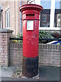
2

Edward VII postbox, Whitley Road
Image: © Mike Quinn
Taken: 24 Sep 2017
0.01 miles
3
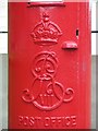
Edward VII postbox, Whitley Road - royal cipher
See Image
Image: © Mike Quinn
Taken: 24 Sep 2017
0.01 miles
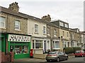
4
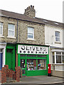
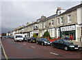
Olivers Bookshop, Whitley Road
Shows the location of Image
Image: © Mike Quinn
Taken: 24 Sep 2017
0.01 miles
5
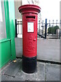
Post Box, Whitley Road, Whitley Bay
This post box dates from the reign of King Edward VII (1901-1910) and is in excellent condition. It stands outside what is currently Oliver's Bookshop. For a selection of detailed free to download walking routes in the area visit www.northtynesidewalks.co.uk
Image: © Geoff Holland
Taken: 30 Jan 2021
0.02 miles
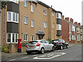
7
Post Box, Margaret Road, Whitley Bay
This post box dates from the reign of Queen Victoria (1837-1901) and stands towards the bottom end of Margaret Road adjacent to the former site of St. Margaret's Methodist Church. For a selection of detailed free to download walking routes in the area visit www.northtynesidewalks.co.uk
Image: © Geoff Holland
Taken: 30 Jan 2021
0.10 miles
8
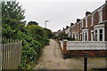
Stanley Crescent
A path along by the railway, now the Metro line, and these houses don't have road access. Some of the land on the left next to the railway is used for gardens and allotments, but most has been allowed to grow wild.
Image: © Bill Boaden
Taken: 17 Sep 2011
0.10 miles
10
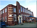
Rockcliffe First School, Whitley Bay
Construction of the present building began in 1910 and it was used for the first time on 1st May 1911. The official opening quickly followed on 10th May 1911. This poem was inspired by my own hazy memories of my time spent at the school:
ROCKCLIFFE REMEMBERED, PERHAPS
The constant roar of the sea,
sandstone & tide,
a freezing north wind & mist
on the high lattice work windows.
Corridors smelling of stale milk
& a class room full of
ruddy-cheeked children,
7-years old & eager to be free,
running wild in the concrete lanes.
Dampness & dust,
cast iron radiators
& the playtime scramble
in the high-walled yard.
Knees grazed,
badges of honour
in the rough & tumble,
& the temptation of
boarded-up shelters,
old war time relics.
A dinner time procession
of post-war baby-boomers,
out in the cold,
hungry for tapioca
& the three o'clock bell.
All seemed well in the world
at the end of our street.
Poem by Geoff Holland
For a selection of detailed free to download walking routes in the area visit www.northtynesidewalks.co.uk
Image: © Geoff Holland
Taken: 30 Jan 2021
0.10 miles