IMAGES TAKEN NEAR TO
Grosvenor Drive, WHITLEY BAY, NE26 2JR
Introduction
This page details the photographs taken nearby to Grosvenor Drive, NE26 2JR by members of the Geograph project.
The Geograph project started in 2005 with the aim of publishing, organising and preserving representative images for every square kilometre of Great Britain, Ireland and the Isle of Man.

There are currently over 7.5m images from over14,400 individuals and you can help contribute to the project by visiting https://www.geograph.org.uk
Image Map
Images are licensed for reuse under creativecommons.org/licenses/by-sa/2.0
Notes
- Clicking on the map will re-center to the selected point.
- The higher the marker number, the further away the image location is from the centre of the postcode.
Image Listing (23 Images Found)
Images are licensed for reuse under creativecommons.org/licenses/by-sa/2.0
Image
Details
Distance
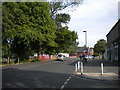
2

Morrisons petrol station, Whitley Bay
Image: © Mark Anderson
Taken: 27 Oct 2019
0.08 miles
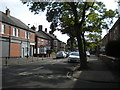
3
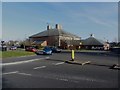
Marden Bridge Sports Centre, Whitley Bay
Looking across Marden Road South to Marden Bridge Sports Centre.
Image: © Graham Robson
Taken: 24 Feb 2018
0.11 miles
4
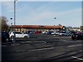
Morrisons supermarket, Whitley Bay
A large Morrisons supermarket and its car park off Hillheads Road.
Image: © Graham Robson
Taken: 24 Feb 2018
0.12 miles

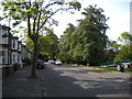
7
South east end of Marmion Terrace, Monkseaton
Leading to Belvedere Avenue.
Image: © Richard Vince
Taken: 22 Jun 2019
0.14 miles
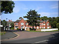
8
Abbotsford Park, Monkseaton
Off Marmion Terrace.
Image: © Richard Vince
Taken: 22 Jun 2019
0.15 miles
10
South end of Village Court, Monkseaton
Private road off Norham Road.
Image: © Richard Vince
Taken: 22 Jun 2019
0.16 miles