IMAGES TAKEN NEAR TO
Linden Terrace, WHITLEY BAY, NE26 2AA
Introduction
This page details the photographs taken nearby to Linden Terrace, NE26 2AA by members of the Geograph project.
The Geograph project started in 2005 with the aim of publishing, organising and preserving representative images for every square kilometre of Great Britain, Ireland and the Isle of Man.

There are currently over 7.5m images from over14,400 individuals and you can help contribute to the project by visiting https://www.geograph.org.uk
Image Map (Loading...)


Getting Data...Please wait
Leaflet Map data © OpenStreetMap
Images are licensed for reuse under creativecommons.org/licenses/by-sa/2.0
Notes
- Clicking on the map will re-center to the selected point.
- The higher the marker number, the further away the image location is from the centre of the postcode.
Image Listing (177 Images Found)
Images are licensed for reuse under creativecommons.org/licenses/by-sa/2.0
Image
Details
Distance
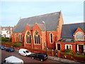
1
Former Trinity United Reformed Church, Esplanade, Whitley Bay
The foundation stone for this church, then known as the Whitley Presbyterian Church, was laid on the 25th April 1900 and the church was opened on the 25th November 1900. The church was closed in 2008 although the adjacent church hall continued to be used. The church building was destroyed by fire on the 6th May, 2017 followed by another fire in the ruins on the 14th June 2020. This photograph shows the main entrance to the church with what little remains of the rose window above. For a selection of detailed free to download walking routes in the area visit www.northtynesidewalks.co.uk
Image: © Geoff Holland
Taken: 30 Jan 2021
0.03 miles
2
Trinity Church, Esplanade, Whitley Bay
Image: © Bill Henderson
Taken: 27 Jul 2016
0.03 miles
3
Former Trinity Church, Esplanade, Whitley Bay
The remains of Trinity Church on Esplanade. A fire gutted the disused church in May 2017 reducing it to the state pictured here. Image shows the church 10 months before it was wrecked by fire.
Image: © Graham Robson
Taken: 24 Feb 2018
0.03 miles
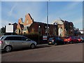
4
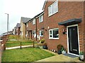
1-12 Esplanade, Whitley Bay
This terrace of 12 houses was developed by Fordinghall Ltd on the site of the former Trinity United Reformed Church, which was destroyed by fire on the 6th May, 2017 https://www.geograph.org.uk/photo/6743805 .
Image: © Geoff Holland
Taken: 8 Oct 2024
0.03 miles
5
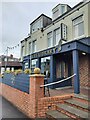
The Library, 19 South Parade, Whitley Bay
The Library is a cosy bar with a sunlit beer garden which serves local craft beers, wines and cocktails. It opened in April 2024.
Image: © Geoff Holland
Taken: 8 Oct 2024
0.04 miles
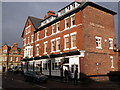
6
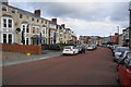
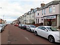
South Parade, Whitley Bay
The centre of the town's night life. The left-hand side of the road is a continual sequence of venues, leading right down to the promenade.
Image: © Bill Boaden
Taken: 17 Sep 2011
0.04 miles
7
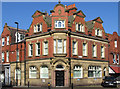
Whitley Bay - ex-bank
On corner of Esplanade and Whitley Road.
Image: © Dave Bevis
Taken: 15 Oct 2011
0.04 miles
9
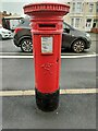
Post Box, South Parade, Whitley Bay
This box dates from the reign of Queen Victoria (1837-1901). The custom of including a royal cypher on post boxes dates back to the very earliest roadside boxes from the reign of Queen Victoria. There was no standard cypher used by the Post Office during this period until, in the 1880s, a consistent cypher began to be seen. Unlike the cyphers of proceeding monarchs, Queen Victoria’s cypher did not usually include a crown. This box was probably erected at some time between 1895 and 1901.
Image: © Geoff Holland
Taken: 8 Oct 2024
0.04 miles