IMAGES TAKEN NEAR TO
Sandringham Close, WHITLEY BAY, NE25 9PB
Introduction
This page details the photographs taken nearby to Sandringham Close, NE25 9PB by members of the Geograph project.
The Geograph project started in 2005 with the aim of publishing, organising and preserving representative images for every square kilometre of Great Britain, Ireland and the Isle of Man.

There are currently over 7.5m images from over14,400 individuals and you can help contribute to the project by visiting https://www.geograph.org.uk
Image Map (Loading...)


Getting Data...Please wait
Leaflet Map data © OpenStreetMap
Images are licensed for reuse under creativecommons.org/licenses/by-sa/2.0
Notes
- Clicking on the map will re-center to the selected point.
- The higher the marker number, the further away the image location is from the centre of the postcode.
Image Listing (9 Images Found)
Images are licensed for reuse under creativecommons.org/licenses/by-sa/2.0
Image
Details
Distance
1
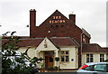
The Beacon Public House, West Monkseaton
An upmarket pub just up the road from Sainsbury's!
Image: © Alan Fearon
Taken: 14 Nov 2005
0.11 miles
3
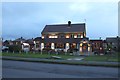
The Beacon, Earsdon Road, West Monkseaton
A pub situated off Earsdon Road in West Monkseaton.
Image: © Graham Robson
Taken: 24 Nov 2018
0.17 miles
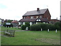
5
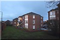
Flats off Rosemount Way, West Monkseaton
Blocks of flats beside Rosemount Way in West Monkseaton.
Image: © Graham Robson
Taken: 24 Nov 2018
0.22 miles
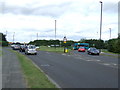
6
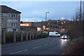
Rosemount Way, West Monkseaton
A street in West Monkseaton. A large Sainsbury's supermarket is visible further down the street.
Image: © Graham Robson
Taken: 24 Nov 2018
0.23 miles
7
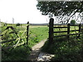
Five Bar Gate, South Wellfield
This open five bar gate leads from Otterburn Avenue, South Wellfield to the South Wellfield Pedestrian Crossing https://www.geograph.org.uk/photo/6448948 along the public footpath shown at https://www.geograph.org.uk/photo/6448960. For a selection of detailed free to download walking routes in the area visit www.northtynesidewalks.co.uk
Image: © Geoff Holland
Taken: 19 Apr 2020
0.23 miles
8
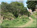
Public Footpath, South Wellfield
This footpath leads from the South Wellfield Pedestrian Crossing https://www.geograph.org.uk/photo/6448948 to Otterburn Avenue, South Wellfield where it then connects with a public footpath leading towards Earsdon village. Ahead, the well-walked path heads through an open five bar gate with the remnants of an earlier small gate and adjacent step stile still visible to the left. For a selection of detailed free to download walking routes in the area visit www.northtynesidewalks.co.uk
Image: © Geoff Holland
Taken: 19 Apr 2020
0.23 miles
9
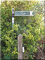
Public Footpath Sign, South Wellfield
This sign stands at the point where the public footpath joins Otterburn Avenue close to the entrance to South Wellfield First School. In the opposite direction, indicated by the sign, the footpath, which is shown at https://www.geograph.org.uk/photo/6451194, heads towards the junction of two public footpaths, next to the sign shown at https://www.geograph.org.uk/photo/6451178. For a selection of detailed free to download walking routes in the area visit www.northtynesidewalks.co.uk
Image: © Geoff Holland
Taken: 22 Apr 2020
0.24 miles