IMAGES TAKEN NEAR TO
Church View, WHITLEY BAY, NE25 9LP
Introduction
This page details the photographs taken nearby to Church View, NE25 9LP by members of the Geograph project.
The Geograph project started in 2005 with the aim of publishing, organising and preserving representative images for every square kilometre of Great Britain, Ireland and the Isle of Man.

There are currently over 7.5m images from over14,400 individuals and you can help contribute to the project by visiting https://www.geograph.org.uk
Image Map (73 Images)


Getting Data...Please wait
Leaflet Map data © OpenStreetMap
Images are licensed for reuse under creativecommons.org/licenses/by-sa/2.0
Notes
- Clicking on the map will re-center to the selected point.
- The higher the marker number, the further away the image location is from the centre of the postcode.
Image Listing (73 Images Found)
Images are licensed for reuse under creativecommons.org/licenses/by-sa/2.0
Image
Details
Distance

2
West View, Earsdon
This terrace first appeared on the 1920 edition (revised 1913-1914) of the Ordnance Survey Six-Inch map of the area and is accessed, at the front, via a narrow footpath. The properties, which have gardens on the other side of the footpath, have unobscured views to the west. For a selection of detailed free to download walking routes in the area visit www.northtynesidewalks.co.uk
Image: © Geoff Holland
Taken: 12 Mar 2021
0.02 miles
3

The Cannon Inn, Earsdon
When the first Ordnance Survey Six-Inch map of the area was published in 1865 (Surveyed in 1858), the Cannon Inn was clearly named on that map. Several French prisoners were held in Earsdon village during the Napoleonic Wars (1803-1815) after a French ship, its crew, and at least one cannon were captured on the nearby River Blyth. It is said that this was when The Spread Eagle in Earsdon changed its name to the Cannon Inn. For a selection of detailed free to download walking routes in the area visit www.northtynesidewalks.co.uk
Image: © Geoff Holland
Taken: 10 Feb 2021
0.03 miles
4

The Cannon Inn, Earsdon
A pub in the middle of Earsdon, on Front Street.
Image: © Graham Robson
Taken: 24 Nov 2018
0.04 miles
5

Farm steading conversion, Earsdon
An old farm steading in Earsdon is in the process of being converted into houses.
Image: © Graham Robson
Taken: 24 Nov 2018
0.04 miles
6
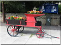
Floral Display, Earsdon
This floral display, which utilises an item of old farming equipment, stands outside St. Alban's Church, Earsdon. For a selection of detailed free to download walking routes in the area visit www.northtynesidewalks.co.uk
Image: © Geoff Holland
Taken: 6 Aug 2020
0.04 miles
7

Post Box, Front Street, Earsdon
This post box on a pedestal dates from the reign of Queen Elizabeth II and stands in front of a property called 'Post House'. The Ordnance Survey Six-Inch map of the area published in 1920 (revised 1913-1914), clearly shows the existence of a post office in this location. For a selection of detailed free to download walking routes in the area visit www.northtynesidewalks.co.uk
Image: © Geoff Holland
Taken: 10 Feb 2021
0.05 miles
8
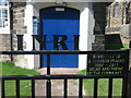
Gate, Edward Eccles Church Hall, Earsdon
The hall, which belongs to St Alban's Church, is located at the west edge of Earsdon. Designed by Wilkinson and Crawley, it was built in 1910-1911 and was a gift to Earsdon by Edward Eccles, J.P. The hall is a Grade II listed building. The gate is a memorial to the late vicar of St Alban's Church who died at the age of 49 years. The initials, 'INRI' come from the Latin phrase "Iesus Nazarenus Rex Iudaeorum" meaning "Jesus of Nazareth, King of the Jews". This was the notice Pontius Pilate nailed over Jesus as he lay dying on the cross. It now signifies that a true Christian lies here. For a selection of detailed free to download walking routes in the area visit www.northtynesidewalks.co.uk
Image: © Geoff Holland
Taken: 6 Aug 2020
0.05 miles
9

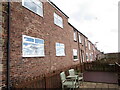
Garden Terrace, Earsdon
A terrace of brick built houses in Earsdon.
Image: © Graham Robson
Taken: 24 Nov 2018
0.06 miles
10

Post House, Earsdon
The old Post Office in Earsdon, now a private house.
Image: © Dale Utterson
Taken: Unknown
0.06 miles