IMAGES TAKEN NEAR TO
Front Street, WHITLEY BAY, NE25 9JZ
Introduction
This page details the photographs taken nearby to Front Street, NE25 9JZ by members of the Geograph project.
The Geograph project started in 2005 with the aim of publishing, organising and preserving representative images for every square kilometre of Great Britain, Ireland and the Isle of Man.

There are currently over 7.5m images from over14,400 individuals and you can help contribute to the project by visiting https://www.geograph.org.uk
Image Map (76 Images)
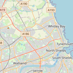


Leaflet Map data © OpenStreetMap
Images are licensed for reuse under creativecommons.org/licenses/by-sa/2.0
Notes
- Clicking on the map will re-center to the selected point.
- The higher the marker number, the further away the image location is from the centre of the postcode.
Image Listing (76 Images Found)
Images are licensed for reuse under creativecommons.org/licenses/by-sa/2.0
Image
Details
Distance
1

Entrance, Manor House, Front Street, Earsdon
The sandstone house, which was built in the mid 18th century, is a Grade II Listed building. The central (renewed) door sits in a flat Tuscan doorcase with a two-storey recess above. The two piers and adjoining quadrant walls are also separately Grade II Listed. The overall effect is one of substantial grandeur. For a selection of detailed free to download walking routes in the area visit www.northtynesidewalks.co.uk
Image: © Geoff Holland
Taken: 12 Mar 2021
0.01 miles
2
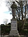
War Memorial, Front Street, Earsdon
Erected in about 1919, this granite memorial with bronze lettering, is Grade II Listed. The statue of a marine stands on a tall, square rock-faced granite plinth and a pedestal with an inset panel containing the names of those locals who died in the Great War (1914 to 1918). For a selection of detailed free to download walking routes in the area visit www.northtynesidewalks.co.uk
Image: © Geoff Holland
Taken: 12 Mar 2021
0.03 miles
3
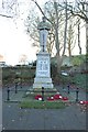
Earsdon War Memorial
The war memorial on Front Street in the small village of Earsdon.
Image: © Graham Robson
Taken: 24 Nov 2018
0.03 miles


7

Earsdon Methodist Church, Front Street, Earsdon
A Primitive Methodist Chapel was first built in Earsdon in 1825, and is shown on the first edition of the Ordnance Survey Six-Inch map of the area published in 1865 as being located immediately behind (south of) what is now the Red Lion Public House. It was replaced by the present stone-built chapel, with schoolroom and vestries, in 1886 and although it appears to be small from this angle it has a large basement and an extension to the rear. For a selection of detailed free to download walking routes in the area visit www.northtynesidewalks.co.uk
Image: © Geoff Holland
Taken: 10 Feb 2021
0.04 miles
8

Front Street, Earsdon
Looking along the main road in the small North Tyneside village of Earsdon.
Image: © Graham Robson
Taken: 24 Nov 2018
0.04 miles
9

Cottages, Church Way, Earsdon
These stone cottages date from the early part of the 19th century and help to create one of the most attractive aspects of Earsdon Village. Two of the cottages have fine half dormers. For a selection of detailed free to download walking routes in the area visit www.northtynesidewalks.co.uk
Image: © Geoff Holland
Taken: 12 Mar 2021
0.04 miles
10

House, Bank Top, Earsdon
This elegant extended stone-built property forms part of a short terrace leading up to the corner of Bank Top and Front Street, Earsdon. It faces the more recently-built Constable Garth https://www.geograph.org.uk/photo/6654925. For a selection of detailed free to download walking routes in the area visit www.northtynesidewalks.co.uk
Image: © Geoff Holland
Taken: 27 Oct 2020
0.04 miles