IMAGES TAKEN NEAR TO
Belsay Avenue, WHITLEY BAY, NE25 8PZ
Introduction
This page details the photographs taken nearby to Belsay Avenue, NE25 8PZ by members of the Geograph project.
The Geograph project started in 2005 with the aim of publishing, organising and preserving representative images for every square kilometre of Great Britain, Ireland and the Isle of Man.

There are currently over 7.5m images from over14,400 individuals and you can help contribute to the project by visiting https://www.geograph.org.uk
Image Map (Loading...)


Getting Data...Please wait
Leaflet Map data © OpenStreetMap
Images are licensed for reuse under creativecommons.org/licenses/by-sa/2.0
Notes
- Clicking on the map will re-center to the selected point.
- The higher the marker number, the further away the image location is from the centre of the postcode.
Image Listing (101 Images Found)
Images are licensed for reuse under creativecommons.org/licenses/by-sa/2.0
Image
Details
Distance
1
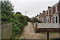
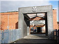
Stanley Crescent
A path along by the railway, now the Metro line, and these houses don't have road access. Some of the land on the left next to the railway is used for gardens and allotments, but most has been allowed to grow wild.
Image: © Bill Boaden
Taken: 17 Sep 2011
0.10 miles
2
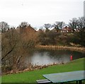
Station Master's Community Wildlife Garden, Whitley Bay
Image: © Andrew Curtis
Taken: 15 Oct 2015
0.14 miles
4

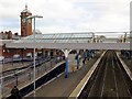
Clock Tower, Whitley Bay Metro Station, Whitley Bay
The station, which was designed by William Bell for the North Eastern Railway Company, was built in 1910 and was described in the 1992 edition of 'The Buildings of England Northumberland' by Nikolaus Pevsner as, "free Baroque, in cheerful brick, ashlar and faience". The description went on to say, "stone garlands abound on the prominent clock tower, which lends some distinction to an undistinguished neighbourhood". The station is a Grade II Listed building. For a selection of detailed free to download walking routes in the area visit www.northtynesidewalks.co.uk
Image: © Geoff Holland
Taken: 30 Jan 2021
0.16 miles
5
Marden Quarry
The east end of Marden Quarry.
Image: © Antonia
Taken: 20 Jan 2008
0.16 miles
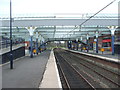
6
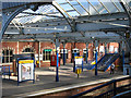
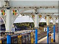
Whitley Bay - Station (platform 1)
Photo taken from western footbridge.
Image: © Dave Bevis
Taken: 15 Oct 2011
0.16 miles
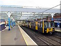
7
Whitley Bay Metro station, Tyne & Wear
Opened in 1882 by the North Eastern Railway on the North Tyneside loop line from Newcastle to Tynemouth, this station was rebuilt in 1910 and converted to Metro operation in 1980.
View east towards Cullercoats and Tynemouth.
Image: © Nigel Thompson
Taken: 10 Apr 2009
0.16 miles