IMAGES TAKEN NEAR TO
Jefferson Grove, WHITLEY BAY, NE25 0QE
Introduction
This page details the photographs taken nearby to Jefferson Grove, NE25 0QE by members of the Geograph project.
The Geograph project started in 2005 with the aim of publishing, organising and preserving representative images for every square kilometre of Great Britain, Ireland and the Isle of Man.

There are currently over 7.5m images from over14,400 individuals and you can help contribute to the project by visiting https://www.geograph.org.uk
Image Map
Images are licensed for reuse under creativecommons.org/licenses/by-sa/2.0
Notes
- Clicking on the map will re-center to the selected point.
- The higher the marker number, the further away the image location is from the centre of the postcode.
Image Listing (30 Images Found)
Images are licensed for reuse under creativecommons.org/licenses/by-sa/2.0
Image
Details
Distance
1
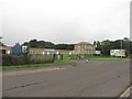
Delcor factory, Seaton Delaval
A furniture factory off Double Row in Seaton Delaval.
Image: © Graham Robson
Taken: 19 Aug 2018
0.08 miles
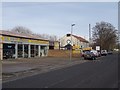
2
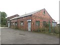
Vacant building, Double Row, Seaton Delaval
A small vacant light industrial unit on Double Row in Seaton Delaval.
Image: © Graham Robson
Taken: 19 Aug 2018
0.10 miles
3
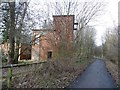
Surviving buildings, Seaton Delaval Colliery
The tarred track is the site of a wagonway, Seaton Delaval Colliery Railway which linked several pits with a common owner. This is the site of the Seaton Delaval Colliery which closed in 1960. Much of the site is covered in woodland.
Image: © Richard Webb
Taken: 26 Jan 2019
0.11 miles
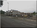
5
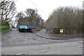
Double Row, Seaton Delaval
Beyond the car dealer there is a former church, mapped as the Mission Church. This was once adjacent to Seaton Delaval Colliery.
Image: © Richard Webb
Taken: 26 Jan 2019
0.13 miles
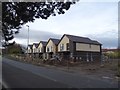
6
New houses, Double Row, Seaton Delaval
A row of new houses under construction on Double Row in Seaton Delaval.
Image: © Graham Robson
Taken: 19 Aug 2018
0.17 miles
7
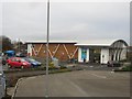
Coop supermarket, Blackhaugh Drive, Seaton Delaval
A modern supermarket, part of the Lakes and Dales branded Cooperative Society in the Wheatridge Park area of Seaton Delaval.
Image: © Graham Robson
Taken: 10 Dec 2016
0.18 miles
8
New building, Double Row
This is the site of a school.
Image: © Richard Webb
Taken: 26 Jan 2019
0.18 miles
9

Site of the colliery headgear, Seaton Delaval
Now wooded, this was the heart of a large colliery which closed in 1960. There is evidence locally that land here was in agricultural use between the closure and planting of the wood.
Image: © Richard Webb
Taken: 26 Jan 2019
0.18 miles
10

Air shaft, Seaton Delaval Colliery
With two methane vents. The colliery site (closed 1960) is now wooded.
Image: © Richard Webb
Taken: 26 Jan 2019
0.19 miles