IMAGES TAKEN NEAR TO
Stable Way, NE25 0GF
Introduction
This page details the photographs taken nearby to Stable Way, NE25 0GF by members of the Geograph project.
The Geograph project started in 2005 with the aim of publishing, organising and preserving representative images for every square kilometre of Great Britain, Ireland and the Isle of Man.

There are currently over 7.5m images from over14,400 individuals and you can help contribute to the project by visiting https://www.geograph.org.uk
Image Map
Images are licensed for reuse under creativecommons.org/licenses/by-sa/2.0
Notes
- Clicking on the map will re-center to the selected point.
- The higher the marker number, the further away the image location is from the centre of the postcode.
Image Listing (17 Images Found)
Images are licensed for reuse under creativecommons.org/licenses/by-sa/2.0
Image
Details
Distance


3

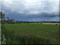
Seaton Red House Farm Near New Hartley
This fine stone property was in situ when the first Ordnance Survey Six-Inch map of the area was published in 1865. For a selection of detailed free to download walking routes in the area visit www.northtynesidewalks.co.uk
Image: © Geoff Holland
Taken: 21 Jul 2020
0.12 miles


7
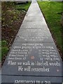
We will remember: path in the Hester Pit Memorial Garden
The plaque reads "In memory of the 204 men and boys who perished in the disaster at the Hester Pit, New Hartley on 16th January 1862."
Two shifts were trapped in the mine by the iron beam of the pumping engine broke blocking the only shaft. This soon led to a law demanding that all pits had at least two shafts and a new colliery was opened to the north. The gardens were opened by Joe Gormley in 1976.
Image: © Richard Webb
Taken: 26 Jan 2019
0.15 miles
8
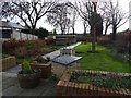
Hester Pit Memorial Garden
The plaque reads "In memory of the 204 men and boys who perished in the disaster at the Hester Pit, New Hartley on 16th January 1862."
Two shifts were trapped in the mine by the iron beam of the pumping engine broke blocking the only shaft. This soon led to a law demanding that all pits had at least two shafts and a new colliery was opened to the north. The gardens were opened by Joe Gormley in 1976.
Probably the most heartbreaking thing I have found when out and about for this site. Old coalfields are fascinating places, but all too often you are reminded of the cost of coal. I am happy that I only married into a mining family and was never required to go down a pit myself.
Image: © Richard Webb
Taken: 26 Jan 2019
0.15 miles

10
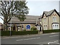
Our Lady & St Joseph's Roman Catholic Church, New Hartley
Image: © Bill Henderson
Taken: 6 May 2012
0.18 miles