IMAGES TAKEN NEAR TO
Park View Student Village, Richardson Road, NEWCASTLE UPON TYNE, NE2 4BY
Introduction
This page details the photographs taken nearby to Park View Student Village, Richardson Road, NE2 4BY by members of the Geograph project.
The Geograph project started in 2005 with the aim of publishing, organising and preserving representative images for every square kilometre of Great Britain, Ireland and the Isle of Man.

There are currently over 7.5m images from over14,400 individuals and you can help contribute to the project by visiting https://www.geograph.org.uk
Image Map
Images are licensed for reuse under creativecommons.org/licenses/by-sa/2.0
Notes
- Clicking on the map will re-center to the selected point.
- The higher the marker number, the further away the image location is from the centre of the postcode.
Image Listing (59 Images Found)
Images are licensed for reuse under creativecommons.org/licenses/by-sa/2.0
Image
Details
Distance
1
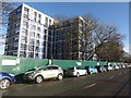
Student accommodation under construction
The old Park View Student Village for Newcastle University has been demolished, and is being replaced with these new blocks, due for completion by September 2018. Space Architects have designed the site with modular living units being constructed off-site prior to assembly into the final buildings.
Image: © Oliver Dixon
Taken: 17 Nov 2017
0.02 miles
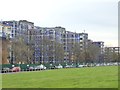
2
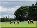
The lowing herd winds slowly oe'r the Leazes
This is central Newcastle: only about 600 m beyond the large trees is Image photographed by Christine Westerback.
Image: © Mike Quinn
Taken: 31 May 2011
0.05 miles
3
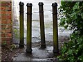
A group of bollards
Is there a collective noun for a group of Bollards? Preventing , very efficiently, unauthorised entry into a back lane near the rear of University buildings.An interesting building named Claremont Cottage is provided with private parking due to the road that this 'cut' leads onto, being closed as a through route.
Image: © David Clark
Taken: 2 Apr 2014
0.05 miles
4
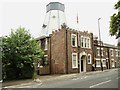
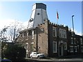
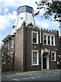
Chimney Mill, Newcastle upon Tyne
This historic windmill was built in 1788. It later became a golf clubhouse. A blue plaque erected by Newcastle City Council outlines its history. I have added a photograph of the blue plaque to this website https://www.geograph.org.uk/photo/2990201.
Image: © Bill Henderson
Taken: 11 Jun 2012
0.08 miles
5
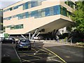
New student accommodation, Richardson Road, Newcastle upon Tyne
One of several new blocks of student flats being built on the site of the Former Richardson Road flats. The new buildings make use of prefabricated bedroom units, the exterior of the building remains to be clad.
Image: © Graham Robson
Taken: 10 Feb 2018
0.08 miles
10
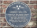
The Blue Plaque, Chimney Mill, Newcastle upon Tyne
Image: © Bill Henderson
Taken: 11 Jun 2012
0.08 miles