IMAGES TAKEN NEAR TO
Edendale Avenue, BLYTH, NE24 5QG
Introduction
This page details the photographs taken nearby to Edendale Avenue, NE24 5QG by members of the Geograph project.
The Geograph project started in 2005 with the aim of publishing, organising and preserving representative images for every square kilometre of Great Britain, Ireland and the Isle of Man.

There are currently over 7.5m images from over14,400 individuals and you can help contribute to the project by visiting https://www.geograph.org.uk
Image Map
Images are licensed for reuse under creativecommons.org/licenses/by-sa/2.0
Notes
- Clicking on the map will re-center to the selected point.
- The higher the marker number, the further away the image location is from the centre of the postcode.
Image Listing (25 Images Found)
Images are licensed for reuse under creativecommons.org/licenses/by-sa/2.0
Image
Details
Distance
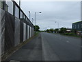
1
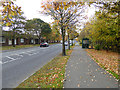
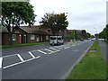
Cowpen Road, Blyth
One of the cycle paths of the Blyth Town cycle network follows the right hand pavement. Trees in autumn colouration.
Image: © Oliver Dixon
Taken: 26 Oct 2015
0.06 miles
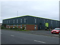
6

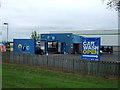
Blyth Valley Retail Park
A modern retail park on Cowpen Road with occupiers including Homebase, Bensons for Beds and Carpetright.
Image: © Graham Robson
Taken: 13 Aug 2022
0.12 miles
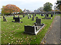
7
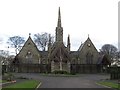
Chapels and Crematorium, Cowpen Cemetery
The building housing the two chapels and crematorium in Cowpen Cemetery. The crematorium is the only one in Northumberland.
Image: © Graham Robson
Taken: 26 Feb 2017
0.14 miles