IMAGES TAKEN NEAR TO
Priory Grange, BLYTH, NE24 5BB
Introduction
This page details the photographs taken nearby to Priory Grange, NE24 5BB by members of the Geograph project.
The Geograph project started in 2005 with the aim of publishing, organising and preserving representative images for every square kilometre of Great Britain, Ireland and the Isle of Man.

There are currently over 7.5m images from over14,400 individuals and you can help contribute to the project by visiting https://www.geograph.org.uk
Image Map
Images are licensed for reuse under creativecommons.org/licenses/by-sa/2.0
Notes
- Clicking on the map will re-center to the selected point.
- The higher the marker number, the further away the image location is from the centre of the postcode.
Image Listing (11 Images Found)
Images are licensed for reuse under creativecommons.org/licenses/by-sa/2.0
Image
Details
Distance
1
Albion Retain Park
On Albion Way. The park is being landscaped.
Image: © Russel Wills
Taken: 26 Jan 2017
0.11 miles
2
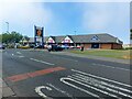
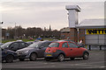
Junction access to shopping park, Blyth
Just out of Blyth town centre there is a small 'out of town' shopping park area with DIY, discount food and furnishing outlet stores. This is the entrance to the car park areas off Albion Way.
Image: © Grahame Jenkins
Taken: 21 Jan 2006
0.11 miles
3
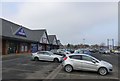
Albion Retail Centre, Cowpen Road, Blyth
A suburban shopping centre in Blyth. Occupiers include Farmfoods and B & M Bargains.
Image: © Graham Robson
Taken: 13 Aug 2022
0.12 miles
4
Albion Way, Blyth
Taken from the top deck of a Park and Ride bus going to Blyth.
Image: © Mark Anderson
Taken: 29 Aug 2016
0.12 miles
5
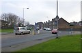
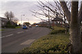
Roundabout on A193 in Blyth
Heading towards Seaton Sluice.
Image: © Russel Wills
Taken: 26 Jan 2017
0.14 miles
6
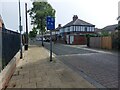
Disraeli Street, Blyth
One of several streets in this part of Blyth named after former UK prime ministers.
Image: © Graham Robson
Taken: 13 Aug 2022
0.17 miles
8
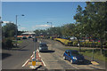
Retail and industrial area north of Blyth town centre
With the A193 Cowpen Road in the background, this is the mixed retail/industrial unit area to the immediate north west of the town centre of Blyth.
Image: © Grahame Jenkins
Taken: 21 Jan 2006
0.24 miles
9
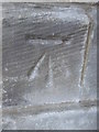
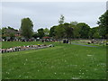
Ordnance Survey Cut Mark
This OS cut mark can be found on the north face of Cowpen Cemetery Chapel. It marks a point 6.602m above mean sea level.
Image: © Adrian Dust
Taken: 9 Oct 2015
0.24 miles
10
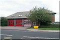
Blyth fire station
Blyth fire station, Cowpen Road, Blyth, Northumberland
Image: © Kevin Hale
Taken: 3 Aug 2010
0.25 miles