IMAGES TAKEN NEAR TO
Buttercup Gardens, BLYTH, NE24 4TS
Introduction
This page details the photographs taken nearby to Buttercup Gardens, NE24 4TS by members of the Geograph project.
The Geograph project started in 2005 with the aim of publishing, organising and preserving representative images for every square kilometre of Great Britain, Ireland and the Isle of Man.

There are currently over 7.5m images from over14,400 individuals and you can help contribute to the project by visiting https://www.geograph.org.uk
Image Map
Images are licensed for reuse under creativecommons.org/licenses/by-sa/2.0
Notes
- Clicking on the map will re-center to the selected point.
- The higher the marker number, the further away the image location is from the centre of the postcode.
Image Listing (12 Images Found)
Images are licensed for reuse under creativecommons.org/licenses/by-sa/2.0
Image
Details
Distance
1
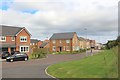
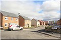
Buttercup Gardens, Portland Wynd, Blyth
The western corner of a new housing development on the western edge of Blyth. Houses on the eastern edge of the development, accessed from Laverock Hall Road, are still being built.
Image: © Graham Robson
Taken: 19 Aug 2018
0.01 miles
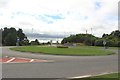
2
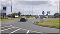
A1061, Blyth
On the edge of Blyth with a roundabout on the junction with Laverock Hall Road. House building is taking place here.
Image: © Richard Webb
Taken: 17 Aug 2019
0.03 miles
3
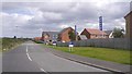
Laverock Hall Road
New houses are being built on the east side of the road, arable farmland is hanging on to the west.
Image: © Richard Webb
Taken: 17 Aug 2019
0.03 miles
4
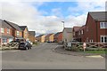
Poppy Drive, Blyth
A newly built street off Laverock Hall Road as part of the Portland Wynd development by Miller Homes. Other parts of the development are still being built.
Image: © Graham Robson
Taken: 19 Aug 2018
0.03 miles
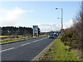
5
Junction between Laverock Hall Road and the A1061, Blyth
A new roundabout at the junction of Laverock Hall Road and the A1061 to the west of Blyth.
Image: © Graham Robson
Taken: 19 Aug 2018
0.05 miles
6
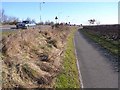
Cramlington to South Beach Cycleway
Here, the cycleway from Cramlington town centre to South Beach in Blyth follows the south side of the A1061, somewhat below road level.
Image: © Oliver Dixon
Taken: 2 Mar 2010
0.05 miles
7
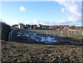
Site cleared for more housing
South west of Blyth.
Image: © Russel Wills
Taken: 22 Feb 2016
0.06 miles
8
A1061 approaching roundabout junction
With Laverock Hall Road.
Image: © Russel Wills
Taken: 22 Feb 2016
0.06 miles
9
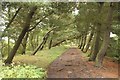
Path on former railway line, Blyth
A footpath following the route of a dismantled railway through the countryside to the west of Blyth. The trees are all leaning to the east, probably due to the effects of the prevailing wind blowing across the open farmland to the west.
Image: © Graham Robson
Taken: 19 Aug 2018
0.11 miles
10
Primrose Gardens, Blyth
A newly built street off Laverock Hall Road, part of a new housing development being built by Miller Homes on the western edge of Blyth.
Image: © Graham Robson
Taken: 19 Aug 2018
0.12 miles