IMAGES TAKEN NEAR TO
Cottingwood Green, BLYTH, NE24 4TF
Introduction
This page details the photographs taken nearby to Cottingwood Green, NE24 4TF by members of the Geograph project.
The Geograph project started in 2005 with the aim of publishing, organising and preserving representative images for every square kilometre of Great Britain, Ireland and the Isle of Man.

There are currently over 7.5m images from over14,400 individuals and you can help contribute to the project by visiting https://www.geograph.org.uk
Image Map
Images are licensed for reuse under creativecommons.org/licenses/by-sa/2.0
Notes
- Clicking on the map will re-center to the selected point.
- The higher the marker number, the further away the image location is from the centre of the postcode.
Image Listing (5 Images Found)
Images are licensed for reuse under creativecommons.org/licenses/by-sa/2.0
Image
Details
Distance
1
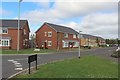
Cargo Close, Newsham, Blyth
A new development of houses between Newcastle Road and the mineral railway line in the Newsham part of Blyth.
Image: © Graham Robson
Taken: 19 Aug 2018
0.04 miles
2
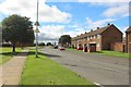
Laverock Hall Road, Blyth
A former council housing estate on the western edge of Blyth.
Image: © Graham Robson
Taken: 19 Aug 2018
0.12 miles
3
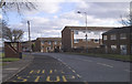
Bus stop at New Delaval
Bus stop and housing at New Delaval, Newsham, Blyth. Looking east along the Laverock Hall Road.
Image: © Grahame Jenkins
Taken: 26 Jan 2006
0.14 miles

5
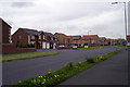
New housing estates south west of Blyth
There are several new housing estates that have been built on the south west corner of Blyth during the last 2-5 years. These bring the two urban areas of Cramlington and Blyth ever closer (satellite photos at night show the gap as almost closed now). This shows the junction of Balmoral Drive and Sweetbriar Way; entrance to the Cavendish Grange Estate built c.2000.
Image: © Grahame Jenkins
Taken: 30 Apr 2005
0.22 miles