IMAGES TAKEN NEAR TO
Front Street, BLYTH, NE24 4HW
Introduction
This page details the photographs taken nearby to Front Street, NE24 4HW by members of the Geograph project.
The Geograph project started in 2005 with the aim of publishing, organising and preserving representative images for every square kilometre of Great Britain, Ireland and the Isle of Man.

There are currently over 7.5m images from over14,400 individuals and you can help contribute to the project by visiting https://www.geograph.org.uk
Image Map
Images are licensed for reuse under creativecommons.org/licenses/by-sa/2.0
Notes
- Clicking on the map will re-center to the selected point.
- The higher the marker number, the further away the image location is from the centre of the postcode.
Image Listing (7 Images Found)
Images are licensed for reuse under creativecommons.org/licenses/by-sa/2.0
Image
Details
Distance
2
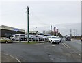
Redburn Motor Company
On Bebside Road at Bebside.
And some pylons!
Image: © Russel Wills
Taken: 19 Feb 2016
0.14 miles
3
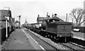
Bebside Station (disused)
View NW, towards Bedlington, Morpeth and Newbiggin; Blyth & Tyne section, Newcastle - Backworth - Morpeth/Newbiggin line, closed (with Bebside station) to passengers 2/11/64 (Bedlington - Morpeth 3/4/50), to goods 7/6/65. Therefore the Up empties train in the photograph, headed by a tender-first ex-NER J27 0-6-0 must have been one of the last.
Image: © Ben Brooksbank
Taken: 12 May 1965
0.16 miles
4
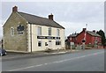
Bebside Inn
Next to the level crossing.
Image: © Russel Wills
Taken: 19 Feb 2016
0.16 miles
5
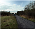
Bebside End Of hatherley Lane (Closed)
Hatherley Lane is closed at the Bebside End by a locked barrier across the lane.
Image: © Kevin Richardson
Taken: 7 Mar 2008
0.18 miles
6
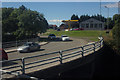
Jet Filling Station, Bebside
Taken from the top deck of a Park and Ride bus going to Blyth.
Image: © Mark Anderson
Taken: 29 Aug 2016
0.20 miles
7
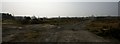
Wasteland.
Site of the Bebside coal disposal point.
Image: © Paul
Taken: 24 Mar 2012
0.22 miles