IMAGES TAKEN NEAR TO
Horton Place, BLYTH, NE24 4BA
Introduction
This page details the photographs taken nearby to Horton Place, NE24 4BA by members of the Geograph project.
The Geograph project started in 2005 with the aim of publishing, organising and preserving representative images for every square kilometre of Great Britain, Ireland and the Isle of Man.

There are currently over 7.5m images from over14,400 individuals and you can help contribute to the project by visiting https://www.geograph.org.uk
Image Map
Images are licensed for reuse under creativecommons.org/licenses/by-sa/2.0
Notes
- Clicking on the map will re-center to the selected point.
- The higher the marker number, the further away the image location is from the centre of the postcode.
Image Listing (13 Images Found)
Images are licensed for reuse under creativecommons.org/licenses/by-sa/2.0
Image
Details
Distance

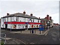
4
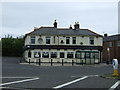
(New) New Delaval
The name New Delaval was first used for rows built on where the golf course is now situated. Image Today's houses were built later and may have been replacements. Looking along Plessy Road, which is the course of the Plessy Old Waggonway.
Image: © Richard Webb
Taken: 26 Jan 2019
0.15 miles
7
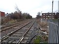
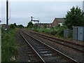
Earsdon and Morpeth Line
A mineral railway running through Blyth. Taken from the level crossing on Plessy Road.
Image: © Richard Webb
Taken: 26 Jan 2019
0.18 miles
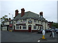
10
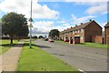
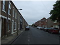
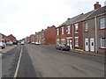
Laverock Hall Road, Blyth
A former council housing estate on the western edge of Blyth.
Image: © Graham Robson
Taken: 19 Aug 2018
0.20 miles