IMAGES TAKEN NEAR TO
Bromley Gardens, BLYTH, NE24 3TT
Introduction
This page details the photographs taken nearby to Bromley Gardens, NE24 3TT by members of the Geograph project.
The Geograph project started in 2005 with the aim of publishing, organising and preserving representative images for every square kilometre of Great Britain, Ireland and the Isle of Man.

There are currently over 7.5m images from over14,400 individuals and you can help contribute to the project by visiting https://www.geograph.org.uk
Image Map
Images are licensed for reuse under creativecommons.org/licenses/by-sa/2.0
Notes
- Clicking on the map will re-center to the selected point.
- The higher the marker number, the further away the image location is from the centre of the postcode.
Image Listing (4 Images Found)
Images are licensed for reuse under creativecommons.org/licenses/by-sa/2.0
Image
Details
Distance
1
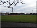
Blyth Rugby and Cricket Club
Big sports ground off Plessy Road. Once on the edge of town according to 1950s 1" maps - it also had a railway running through it.
Image: © Richard Webb
Taken: 26 Jan 2019
0.14 miles
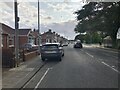
3
Dunblane Drive, Blyth
Part of a large housing development on the south side of the town.
Image: © Chris Heaton
Taken: 23 Jul 2008
0.15 miles
4
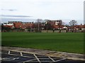
Bede Academy playing fields
There were school buildings here once as well as the playing field. Bede Academy is in the background.
Image: © Richard Webb
Taken: 26 Jan 2019
0.19 miles