IMAGES TAKEN NEAR TO
Solingen Estate, BLYTH, NE24 3ER
Introduction
This page details the photographs taken nearby to Solingen Estate, NE24 3ER by members of the Geograph project.
The Geograph project started in 2005 with the aim of publishing, organising and preserving representative images for every square kilometre of Great Britain, Ireland and the Isle of Man.

There are currently over 7.5m images from over14,400 individuals and you can help contribute to the project by visiting https://www.geograph.org.uk
Image Map
Images are licensed for reuse under creativecommons.org/licenses/by-sa/2.0
Notes
- Clicking on the map will re-center to the selected point.
- The higher the marker number, the further away the image location is from the centre of the postcode.
Image Listing (5 Images Found)
Images are licensed for reuse under creativecommons.org/licenses/by-sa/2.0
Image
Details
Distance
1
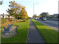
Rotary Way, Blyth
The A193 with cycleway and footway alongside.
Image: © Oliver Dixon
Taken: 26 Oct 2015
0.17 miles
2
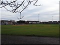
Blyth Rugby and Cricket Club
Big sports ground off Plessy Road. Once on the edge of town according to 1950s 1" maps - it also had a railway running through it.
Image: © Richard Webb
Taken: 26 Jan 2019
0.23 miles
3
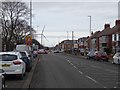
Plessy Road, Blyth
The B1523, a road which has changed identity a few times historically. Wind turbines are very much a theme in Blyth.
Image: © Richard Webb
Taken: 26 Jan 2019
0.23 miles
4
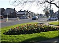
Blyth works on having a pleasant environment
Roundabout with flowers where A193 Broadway and B1327 Plessey Road cross.
Image: © Russel Wills
Taken: 22 Feb 2016
0.24 miles
5
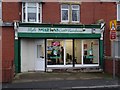
Blyth Smartens
A barbers opposite Croft Park, home of the legendary Blyth Spartans FC.
Image: © Richard Webb
Taken: 26 Jan 2019
0.24 miles