IMAGES TAKEN NEAR TO
Plessey Road, BLYTH, NE24 3AD
Introduction
This page details the photographs taken nearby to Plessey Road, NE24 3AD by members of the Geograph project.
The Geograph project started in 2005 with the aim of publishing, organising and preserving representative images for every square kilometre of Great Britain, Ireland and the Isle of Man.

There are currently over 7.5m images from over14,400 individuals and you can help contribute to the project by visiting https://www.geograph.org.uk
Image Map
Images are licensed for reuse under creativecommons.org/licenses/by-sa/2.0
Notes
- Clicking on the map will re-center to the selected point.
- The higher the marker number, the further away the image location is from the centre of the postcode.
Image Listing (154 Images Found)
Images are licensed for reuse under creativecommons.org/licenses/by-sa/2.0
Image
Details
Distance
2
Plessey Road
Looking towards the quayside in Blyth.
Image: © DS Pugh
Taken: 10 Aug 2019
0.02 miles

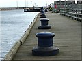
5
Quayside bollard
Bollard on the quay at Blyth.
Image: © Helen Wilkinson
Taken: 19 Oct 2007
0.03 miles
6

Blyth Harbour Commissioner's Offices, Bridge Street, Blyth
Designed in 1913 by Cackett, Burns Dick, Architects of Newcastle Upon Tyne, who also designed the Spanish City in Whitley Bay https://www.geograph.org.uk/photo/5956418, this brick and stone building is Grade II Listed.
Image: © Geoff Holland
Taken: 22 Dec 2020
0.03 miles
7

Decorative Panel
Detail from the fence at Blyth Harbour. The theme of a ship is carried throughout this area
Image: © Christine Westerback
Taken: 24 Feb 2008
0.03 miles
8
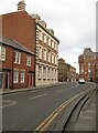
Bridge Street, Blyth
The tall, imposing building on the left on the corner of Bridge Street and Plessey Road is the former Harbour Commissioner's Office, built in 1913 and Grade II listed. There is an Ordnance Survey flush bracket benchmark on the plinth of the building facing onto Bridge Street (detail photograph Image).
This part of Bridge Street was renamed from Blagdon Street.
Image: © Adrian Taylor
Taken: 23 Feb 2008
0.03 miles
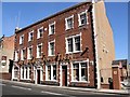
9

Former Kings Head Hotel, Bridge Street, Blyth
Built in the late 19th century, the former Kings Head Hotel has been described as, "an exuberant Free Baroque stone finished building decorated by Greek motifs including Ionic pilasters and a Greek key frieze". It is a Grade II Listed building.
Image: © Geoff Holland
Taken: 22 Dec 2020
0.03 miles
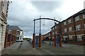
10

The Main Stage, Blyth Tall Ships event
As part of the festivities marking the visit of the flotilla of Tall Ships which make up the 2016 North Sea Tall Ships Regatta several stages were erected around the town to provide entertainment to the crowds of people in attendance. Pictured here is the main stage.
Image: © Graham Robson
Taken: 29 Aug 2016
0.03 miles