
IMAGES TAKEN NEAR TO
Sussex Street, BLYTH, NE24 2BD
Introduction
This page details the photographs taken nearby to Sussex Street, NE24 2BD by members of the Geograph project.
The Geograph project started in 2005 with the aim of publishing, organising and preserving representative images for every square kilometre of Great Britain, Ireland and the Isle of Man.

There are currently over 7.5m images from over14,400 individuals and you can help contribute to the project by visiting https://www.geograph.org.uk
Image Map
Images are licensed for reuse under creativecommons.org/licenses/by-sa/2.0
Notes
- Clicking on the map will re-center to the selected point.
- The higher the marker number, the further away the image location is from the centre of the postcode.
Image Listing (147 Images Found)
Images are licensed for reuse under creativecommons.org/licenses/by-sa/2.0
Image
Details
Distance
1
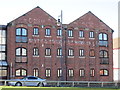
The former Blyth & Tyne Brewery building, Blyth
Image: © Ian S
Taken: 2 Feb 2013
0.00 miles
3
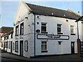
The Quay (Boathouse Tavern), Bridge Street, Blyth
This public house was probably built in the late 17th century although it has, since then, undergone some alteration. It is a Grade II Listed building. It was originally attached to Blyth Brewery which stood immediately behind it. The brewery was demolished in the 1960s.
Image: © Geoff Holland
Taken: 22 Dec 2020
0.02 miles
5
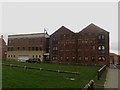
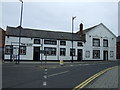
Former bonded Warehouse, Blyth
This large brick building is a former bonded warehouse at the Port of Blyth. The fading large white paint sign on the building suggests that it once belonged to the Blyth and Tyne Brewery Company.
Image: © Graham Robson
Taken: 20 Feb 2016
0.02 miles

7
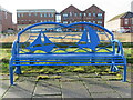
Decorative Seating, Blyth Harbour
This decorative seating reflects the sailing traditions connected with Blyth. In the background stands the imposing building of the former Blyth & Tyne Brewery Co. Ltd.
Image: © Geoff Holland
Taken: 22 Dec 2020
0.04 miles
8
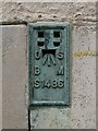
Benchmark, Bridge Street
Detail of the Ordnance Survey flush bracket benchmark on the northwest corner of the southwest face of the former Harbour Commissioner's Offices on Bridge Street. The flush bracket, benchmark number S1486, marks a height of 6.0074m above mean sea level (Ordnance Datum Newlyn), last levelled for height in 1960 and verified in 1965 (location photograph Image).
Traces of yellow waxed crayon and a faint horizontal pencilled line are evident adjacent to the benchmark, most likely applied when the bench mark was recently used as a survey datum.
Image: © Adrian Taylor
Taken: 23 Feb 2008
0.04 miles
9

Ordnance Survey Flush Bracket (S1486)
This OS Flush Bracket can be found on the SW face of the Harbour Commissioners Office. It marks a point 6.007m above mean sea level.
Image: © Adrian Dust
Taken: 9 Oct 2015
0.04 miles
10
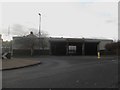
Arriva bus depot, Blyth
A large garage in the centre of Blyth owned by Arriva North East who operate local and regional services using buses housed at the depot.
Image: © Graham Robson
Taken: 20 Feb 2016
0.04 miles