IMAGES TAKEN NEAR TO
Wimbourne Quay, BLYTH, NE24 1PX
Introduction
This page details the photographs taken nearby to Wimbourne Quay, NE24 1PX by members of the Geograph project.
The Geograph project started in 2005 with the aim of publishing, organising and preserving representative images for every square kilometre of Great Britain, Ireland and the Isle of Man.

There are currently over 7.5m images from over14,400 individuals and you can help contribute to the project by visiting https://www.geograph.org.uk
Image Map
Images are licensed for reuse under creativecommons.org/licenses/by-sa/2.0
Notes
- Clicking on the map will re-center to the selected point.
- The higher the marker number, the further away the image location is from the centre of the postcode.
Image Listing (39 Images Found)
Images are licensed for reuse under creativecommons.org/licenses/by-sa/2.0
Image
Details
Distance
1
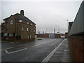
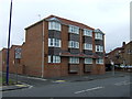
Outside Wimbourne Quay
Regent Street or the B1239 outside Wimbourne Quay, which is part of the Port of Blyth. The road makes a sharp right angled turn to become Hodgsons Road.
Image: © Chris Heaton
Taken: 19 Aug 2008
0.04 miles

3
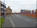
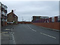
Regent Street, Blyth
National Cycle Network route 1 (Coast and Castles) follows this street. The wall and fence to the right demarcate the Port of Blyth.
Image: © Oliver Dixon
Taken: 26 Oct 2015
0.06 miles
5
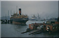
Blyth chain ferry, 1960
Scanned from an old slide of my father's, my mother reckoned this was the Tyne ferry at South Shields, but thanks to other geograph contributors it has been demonstrated from other sources to be the south bank end of the Blyth chain ferry. The chimneys in the distance are the Cambois power station. Both that and the ferry no longer exist although Image shows the remaining industrial archaeology.
See http://www.chroniclelive.co.uk/north-east-news/todays-evening-chronicle/2009/11/20/river-blyth-ferry-plan-sunk-over-high-costs-72703-25214522/ and http://www.redbubble.com/people/blythart/art/3484807-5-179-high-ferry-blyth-dave-edwards-ink-1990 and
http://www.rootschat.com/forum/index.php?PHPSESSID=nuvi15kcfplkrli2t58bou27d1&topic=426111.0
Image: © Frederick W Craven
Taken: Unknown
0.07 miles
6

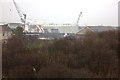
Fugro Saltire in Blyth Harbour
The Fugro Saltire is a purpose built ROV (Remotely Operated underwater Vehicle) support vessel, that has been specifically designed to address the latest demands of the Trenching, deep water Remote Intervention, Construction & Survey markets.
Image: © Russel Wills
Taken: 10 Feb 2016
0.07 miles
10
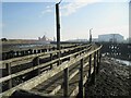
Wooden Walkway around Dismantled Coal Staith
Where is the blue plaque --- Jack Carter was here.
Image: © Les Hull
Taken: 14 Feb 2023
0.12 miles