IMAGES TAKEN NEAR TO
Grieve Street, BLYTH, NE24 1NT
Introduction
This page details the photographs taken nearby to Grieve Street, NE24 1NT by members of the Geograph project.
The Geograph project started in 2005 with the aim of publishing, organising and preserving representative images for every square kilometre of Great Britain, Ireland and the Isle of Man.

There are currently over 7.5m images from over14,400 individuals and you can help contribute to the project by visiting https://www.geograph.org.uk
Image Map
Images are licensed for reuse under creativecommons.org/licenses/by-sa/2.0
Notes
- Clicking on the map will re-center to the selected point.
- The higher the marker number, the further away the image location is from the centre of the postcode.
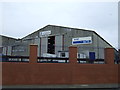
Image Listing (30 Images Found)
Images are licensed for reuse under creativecommons.org/licenses/by-sa/2.0
Image
Details
Distance
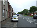
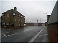
3
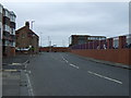
Regent Street, Blyth
National Cycle Network route 1 (Coast and Castles) follows this street. The wall and fence to the right demarcate the Port of Blyth.
Image: © Oliver Dixon
Taken: 26 Oct 2015
0.05 miles
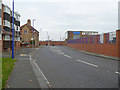
4
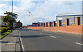
Outside Wimbourne Quay
Regent Street or the B1239 outside Wimbourne Quay, which is part of the Port of Blyth. The road makes a sharp right angled turn to become Hodgsons Road.
Image: © Chris Heaton
Taken: 19 Aug 2008
0.06 miles