IMAGES TAKEN NEAR TO
Brentwood Avenue, NEWCASTLE UPON TYNE, NE2 3DQ
Introduction
This page details the photographs taken nearby to Brentwood Avenue, NE2 3DQ by members of the Geograph project.
The Geograph project started in 2005 with the aim of publishing, organising and preserving representative images for every square kilometre of Great Britain, Ireland and the Isle of Man.

There are currently over 7.5m images from over14,400 individuals and you can help contribute to the project by visiting https://www.geograph.org.uk
Image Map
Images are licensed for reuse under creativecommons.org/licenses/by-sa/2.0
Notes
- Clicking on the map will re-center to the selected point.
- The higher the marker number, the further away the image location is from the centre of the postcode.
Image Listing (92 Images Found)
Images are licensed for reuse under creativecommons.org/licenses/by-sa/2.0
Image
Details
Distance
1
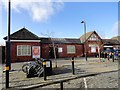
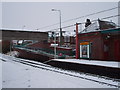
West Jesmond Metro Station
The Metro was opened in 1980, but, as can be seen, the station building is much older than that. In fact it was built in 1900, as a station on North East Railway's Coast Line from Newcastle city centre to Whitley Bay.
Image: © Robert Graham
Taken: 10 Feb 2020
0.01 miles
2
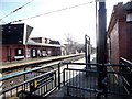
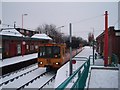
West Jesmond Station platform
Part of the Tyne and Wear Metro railway. This is the busiest station on the line with over one million boardings a year, although it looks quiet on this mid morning in February.
Image: © Robert Graham
Taken: 10 Feb 2020
0.01 miles
3
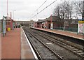
West Jesmond Metro station, Tyne & Wear
Opened in 1900 by the North Eastern Railway on what became the North Tyneside loop line from Newcastle to Tynemouth, this station was rebuilt and converted to Metro operation in 1980.
View north towards Ilford Road and Tynemouth, also the branch to Newcastle Airport.
Image: © Nigel Thompson
Taken: 23 Jan 2010
0.01 miles
4
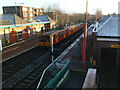
A Metro leaves West Jesmond Station
It was built by the North Eastern Railway company as a heavy rail station, and opened in December 1900. The station platforms are on opposite sides of the line and are linked by an underground pedestrian subway.
The platforms originally had glass awnings to shelter passengers, but these were removed in the 1970s. The sawn-off remnants of these awnings can still be seen attached to the station buildings.
The station closed in 1978 for conversion to Metro service, reopening in August 1980. The original station buildings were kept, but the platforms were shortened and a new footbridge was built over the line.
Image: © Matthew Hatton
Taken: 30 Nov 2008
0.01 miles
5
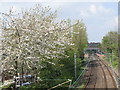
The Metro lines south of West Jesmond Station
Image: © Mike Quinn
Taken: 29 Apr 2009
0.02 miles
6
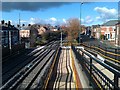
Lots of lines at West Jesmond
Mostly metro lines and handrails.
Image: © David Martin
Taken: 16 Feb 2014
0.02 miles
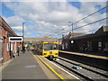
8
South-bound train waiting at West Jesmond Metro station
This photograph shows a south-bound Metro train waiting at West Jesmond station en route for Newcastle City Centre and, subsequently, stations beyond.
Image: © Philip Barker
Taken: 2 Jan 2010
0.02 miles
9
West Jesmond Metro Station
This photograph shows the platform for south-bound Metro trains at West Jesmond station. It also shows the pedestrian footbridge and access ramps to enable passengers to pass between the platforms used for north-bound and south-bound trains.
Image: © Philip Barker
Taken: 2 Jan 2010
0.03 miles
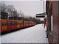
10
Train at West Jesmond Metro Station
This photograph shows a north-bound Metro train waiting at West Jesmond station. Trains using this platform will go either to Newcastle Airport or to the east coast. This particular train is heading for the coast.
Image: © Philip Barker
Taken: 2 Jan 2010
0.04 miles