IMAGES TAKEN NEAR TO
Coach House Lane, NEWCASTLE UPON TYNE, NE2 3AX
Introduction
This page details the photographs taken nearby to Coach House Lane, NE2 3AX by members of the Geograph project.
The Geograph project started in 2005 with the aim of publishing, organising and preserving representative images for every square kilometre of Great Britain, Ireland and the Isle of Man.

There are currently over 7.5m images from over14,400 individuals and you can help contribute to the project by visiting https://www.geograph.org.uk
Image Map
Images are licensed for reuse under creativecommons.org/licenses/by-sa/2.0
Notes
- Clicking on the map will re-center to the selected point.
- The higher the marker number, the further away the image location is from the centre of the postcode.
Image Listing (108 Images Found)
Images are licensed for reuse under creativecommons.org/licenses/by-sa/2.0
Image
Details
Distance
1
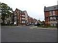
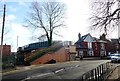
Henshellwood Terrace
A little terraced row in Jesmond. From a look at the old maps, it would seem to be Edwardian in date, from the early years of the 20th century. These would have been built as middle class houses.
Image: © Robert Graham
Taken: 10 Feb 2020
0.02 miles
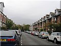
3
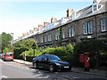
Suburban road, Jesmond
View is looking north up Tankerville Terrace, with St Andrew's and Jesmond Cemetery behind the stone wall ahead. Jesmond was created in the late 19th and early 20th centuries, as housing for the middle classes.
Image: © Robert Graham
Taken: 10 Feb 2020
0.06 miles
4
Footbridge over the Metro
At Tankerville Terrace, Jesmond.
Image: © Robert Graham
Taken: 10 Feb 2020
0.07 miles
5
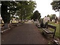
Path, St Andrew's Cemetery, Jesmond, Newcastle upon Tyne
The main path running east to west through the middle of St Andrew's Cemetery.
Image: © Graham Robson
Taken: 9 Jun 2020
0.08 miles
6
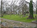
St Andrews Cemetery
In April 1855 the Burial Board agreed to purchase ground for a cemetery from the Hospital of St Mary Magdalene. The designer was Middleton and Prichett of Darlington. The first burials took place in 1857. Initially known as St Andrew's and Jesmond Cemetery the name is given as St Andrew's Cemetery on the 1861 Ordnance Survey map.
Image: © Russel Wills
Taken: 7 Apr 2021
0.08 miles
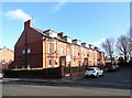
8
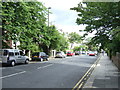
Osborne Road (B1600), Jesmond
Heading north.
Image: © JThomas
Taken: 3 Aug 2013
0.09 miles
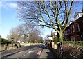
9
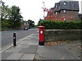
Anonymous postbox (NE2 47D)
The postbox (NE2 47D) on the corner of Osbourne Road (B1600) and Holly Avenue doesn't carry a royal cypher.
Image: © Gerald England
Taken: 16 Oct 2022
0.09 miles