IMAGES TAKEN NEAR TO
NE23 9HY
Introduction
This page details the photographs taken nearby to NE23 9HY by members of the Geograph project.
The Geograph project started in 2005 with the aim of publishing, organising and preserving representative images for every square kilometre of Great Britain, Ireland and the Isle of Man.

There are currently over 7.5m images from over14,400 individuals and you can help contribute to the project by visiting https://www.geograph.org.uk
Image Map
Images are licensed for reuse under creativecommons.org/licenses/by-sa/2.0
Notes
- Clicking on the map will re-center to the selected point.
- The higher the marker number, the further away the image location is from the centre of the postcode.
Image Listing (5 Images Found)
Images are licensed for reuse under creativecommons.org/licenses/by-sa/2.0
Image
Details
Distance
1
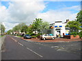
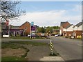
Nelson Village, South East Northumberland
The village owes its name to the nearby but long since closed Nelson Colliery.
The photograph shows the Post Office / general store on Arcot Avenue.
Image: © Chris Tweedy
Taken: 1 May 2003
0.00 miles
2
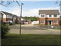
New houses, Cramlington
A new housing development, part of which has been completed and is occupied, in Cramlington.
Image: © Graham Robson
Taken: 15 May 2016
0.22 miles
3
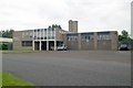
Cramlington old fire station
Cramlington old fire station, South Nelson Road, South Nelson Ind Est, Cramlington, Northumberland
Image: © Kevin Hale
Taken: 3 Aug 2010
0.23 miles
4
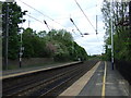
East Coast Main Line heading north from Cramlington Station
Image: © JThomas
Taken: 2 Jun 2012
0.25 miles
5
New housing development, Cramlington
A new housing development under construction in Cramlington.
Image: © Graham Robson
Taken: 15 May 2016
0.25 miles