IMAGES TAKEN NEAR TO
Elgin Close, CRAMLINGTON, NE23 8JA
Introduction
This page details the photographs taken nearby to Elgin Close, NE23 8JA by members of the Geograph project.
The Geograph project started in 2005 with the aim of publishing, organising and preserving representative images for every square kilometre of Great Britain, Ireland and the Isle of Man.

There are currently over 7.5m images from over14,400 individuals and you can help contribute to the project by visiting https://www.geograph.org.uk
Image Map (9 Images)


Getting Data...Please wait
Leaflet Map data © OpenStreetMap
Images are licensed for reuse under creativecommons.org/licenses/by-sa/2.0
Notes
- Clicking on the map will re-center to the selected point.
- The higher the marker number, the further away the image location is from the centre of the postcode.
Image Listing (9 Images Found)
Images are licensed for reuse under creativecommons.org/licenses/by-sa/2.0
Image
Details
Distance
1
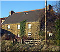
Beacon Farm, Cramlington
On Beaconhill just on the edge of the 'New Town'
Image: © Alan Fearon
Taken: 15 Nov 2005
0.08 miles
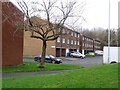
4
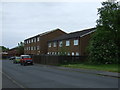
Esher Place, Beaconhill Lea
A Cramlington housing estate.
Image: © Richard Webb
Taken: 26 Jan 2019
0.11 miles
6

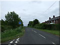
Shop, Keele Drive
Edge of Beaconhill, Cramlington. The intention to expand the town westward is obvious.
Image: © Richard Webb
Taken: 26 Jan 2019
0.15 miles
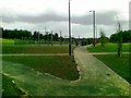
7
Park, Beaconhill Green
A big informal green space to the north of Beacon Farm, which farmed this land before the new town.
Image: © Richard Webb
Taken: 26 Jan 2019
0.16 miles
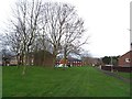
8
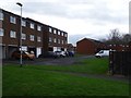
Evesham Place, Beaconhill
On the western edge of Cramlington.
Image: © Richard Webb
Taken: 26 Jan 2019
0.16 miles
9
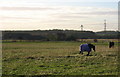
Field, horses and White Hall Farm
Taken from Beaconhill
Image: © Alan Fearon
Taken: 15 Nov 2005
0.25 miles