IMAGES TAKEN NEAR TO
Woking Crescent, NE23 8EZ
Introduction
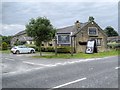
This page details the photographs taken nearby to Woking Crescent, NE23 8EZ by members of the Geograph project.
The Geograph project started in 2005 with the aim of publishing, organising and preserving representative images for every square kilometre of Great Britain, Ireland and the Isle of Man.

There are currently over 7.5m images from over14,400 individuals and you can help contribute to the project by visiting https://www.geograph.org.uk
Image Map
Images are licensed for reuse under creativecommons.org/licenses/by-sa/2.0
Notes
- Clicking on the map will re-center to the selected point.
- The higher the marker number, the further away the image location is from the centre of the postcode.
Image Listing (6 Images Found)
Images are licensed for reuse under creativecommons.org/licenses/by-sa/2.0
Image
Details
Distance
6
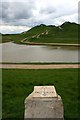
Face Value
A viewpoint at Northumberlandia, an impressive earth sculpture created from the soil from an adjacent open cast coal working. This view is taken looking over the lake to her right knee and towards her head, where her nose and one eye are just visible.
Image: © Graham Hogg
Taken: 11 May 2014
0.25 miles