IMAGES TAKEN NEAR TO
Bovey Castle Place, NE23 8BL
Introduction
This page details the photographs taken nearby to Bovey Castle Place, NE23 8BL by members of the Geograph project.
The Geograph project started in 2005 with the aim of publishing, organising and preserving representative images for every square kilometre of Great Britain, Ireland and the Isle of Man.

There are currently over 7.5m images from over14,400 individuals and you can help contribute to the project by visiting https://www.geograph.org.uk
Image Map (Loading...)


Getting Data...Please wait
Leaflet Map data © OpenStreetMap
Images are licensed for reuse under creativecommons.org/licenses/by-sa/2.0
Notes
- Clicking on the map will re-center to the selected point.
- The higher the marker number, the further away the image location is from the centre of the postcode.
Image Listing (14 Images Found)
Images are licensed for reuse under creativecommons.org/licenses/by-sa/2.0
Image
Details
Distance
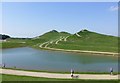
4
Face Value
A viewpoint at Northumberlandia, an impressive earth sculpture created from the soil from an adjacent open cast coal working. This view is taken looking over the lake to her right knee and towards her head, where her nose and one eye are just visible.
Image: © Graham Hogg
Taken: 11 May 2014
0.21 miles
5
Pond at the foot of Northumberlandia
Northumberlandia has been created from a range of carefully selected material from the adjacent Shotton Surface Mine.
There are 6.5km of paths on and around Northumberlandia, enabling visitors to
enjoy walking a range of different routes over the landform.
Image: © Russel Wills
Taken: 26 Aug 2013
0.22 miles
6
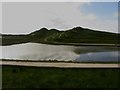
Lake beside Northumberlandia
The lake in the foreground is one of several beside the Northumberlandia sculpture.
Image: © Graham Robson
Taken: 15 May 2016
0.22 miles
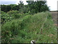
7
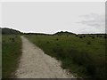
Footpath towards Northumberlandia
Looking along the footpath from Cramlington looking towards the Northumberlandia landform sculpture.
Image: © Graham Robson
Taken: 15 May 2016
0.23 miles
9
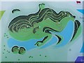
Map of Northumberlandia
This map might help viewers to identify the various portions of the anatomy of "Northumberlandia" seen elsewhere on this site.
Image: © Oliver Dixon
Taken: 2 Feb 2013
0.24 miles
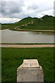
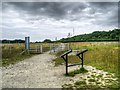
10
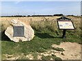
Site of former Cramlington Airfield
Plaque and Information Board at the site of the former Cramlington Airfield.
Image: © David Robinson
Taken: 21 Sep 2020
0.24 miles