IMAGES TAKEN NEAR TO
Station Road, CRAMLINGTON, NE23 8BJ
Introduction
This page details the photographs taken nearby to Station Road, NE23 8BJ by members of the Geograph project.
The Geograph project started in 2005 with the aim of publishing, organising and preserving representative images for every square kilometre of Great Britain, Ireland and the Isle of Man.

There are currently over 7.5m images from over14,400 individuals and you can help contribute to the project by visiting https://www.geograph.org.uk
Image Map
Images are licensed for reuse under creativecommons.org/licenses/by-sa/2.0
Notes
- Clicking on the map will re-center to the selected point.
- The higher the marker number, the further away the image location is from the centre of the postcode.
Image Listing (10 Images Found)
Images are licensed for reuse under creativecommons.org/licenses/by-sa/2.0
Image
Details
Distance
1
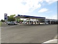
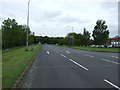
Fuel filling station, Cramlington
A fuel filling station beside the A1172 road in Cramlington. The station is under the Gulf brand and is also a Ford car dealership.
Image: © Graham Robson
Taken: 15 May 2016
0.08 miles
2
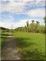
Path under Pylons
A footpath passes along the land which has been left undeveloped under a high voltage power line on the western edge of Cramlington.
Image: © Graham Robson
Taken: 15 May 2016
0.15 miles
3

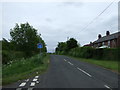
Shop, Keele Drive
Edge of Beaconhill, Cramlington. The intention to expand the town westward is obvious.
Image: © Richard Webb
Taken: 26 Jan 2019
0.16 miles
4
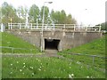
Underpass under Nelson Drive, Cramlington
One of the many underpasses in Cramlington. I suspect these have their origin in the original design of the town as a New Town in the 1960s and an attempt to keep pedestrian traffic separate from road traffic. This doesn't make navigating the town easy as a pedestrian though.
Image: © Graham Robson
Taken: 15 May 2016
0.18 miles
5
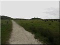
Footpath towards Northumberlandia
Looking along the footpath from Cramlington looking towards the Northumberlandia landform sculpture.
Image: © Graham Robson
Taken: 15 May 2016
0.18 miles
6
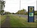
Entering Cramlington Industrial Zone
As Cramlington was conceived as a New Town in the 1960s it has a distinct industrial zone in the north western quarter of the town. The sign here marks the main entrance point to the industrial zone from the south western access roads.
Image: © Graham Robson
Taken: 15 May 2016
0.20 miles
10
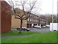
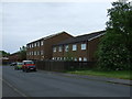
Evesham Place, Beaconhill
On the western edge of Cramlington.
Image: © Richard Webb
Taken: 26 Jan 2019
0.24 miles