IMAGES TAKEN NEAR TO
Ruabon Close, CRAMLINGTON, NE23 7XG
Introduction
This page details the photographs taken nearby to Ruabon Close, NE23 7XG by members of the Geograph project.
The Geograph project started in 2005 with the aim of publishing, organising and preserving representative images for every square kilometre of Great Britain, Ireland and the Isle of Man.

There are currently over 7.5m images from over14,400 individuals and you can help contribute to the project by visiting https://www.geograph.org.uk
Image Map
Images are licensed for reuse under creativecommons.org/licenses/by-sa/2.0
Notes
- Clicking on the map will re-center to the selected point.
- The higher the marker number, the further away the image location is from the centre of the postcode.
Image Listing (7 Images Found)
Images are licensed for reuse under creativecommons.org/licenses/by-sa/2.0
Image
Details
Distance
1
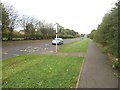
Path alongside the A1171, Cramlington
Looking along the footpath alongside the A1171 road which is the main road into Cramlington from the south.
Image: © Graham Robson
Taken: 8 Oct 2017
0.07 miles
2
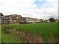
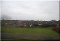
Houses, Grindon Close, Cramlington
Terraced houses in Cramlington.
Image: © Graham Robson
Taken: 8 Oct 2017
0.14 miles
6
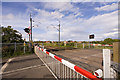
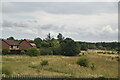
Damdykes Crossing
Damdykes level crossing.
Image: © Craig Allan
Taken: 2 Aug 2008
0.23 miles
7
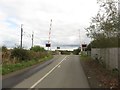
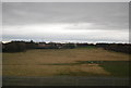
Level crossing, Arcot Lane, Cramlington
A level crossing carrying the East Coast Mainline railway across Arcot Lane a short distance to the west of Cramlington.
Image: © Graham Robson
Taken: 8 Oct 2017
0.23 miles