IMAGES TAKEN NEAR TO
Crofters Close, CRAMLINGTON, NE23 7RJ
Introduction
This page details the photographs taken nearby to Crofters Close, NE23 7RJ by members of the Geograph project.
The Geograph project started in 2005 with the aim of publishing, organising and preserving representative images for every square kilometre of Great Britain, Ireland and the Isle of Man.

There are currently over 7.5m images from over14,400 individuals and you can help contribute to the project by visiting https://www.geograph.org.uk
Image Map
Images are licensed for reuse under creativecommons.org/licenses/by-sa/2.0
Notes
- Clicking on the map will re-center to the selected point.
- The higher the marker number, the further away the image location is from the centre of the postcode.
Image Listing (11 Images Found)
Images are licensed for reuse under creativecommons.org/licenses/by-sa/2.0
Image
Details
Distance
1
Fordley Community Primary School seen from the path and cycleway between Dudley and Annitsford
Image: © habiloid
Taken: 8 Aug 2021
0.11 miles
3
Fordley Community Primary School seen from the path and cycleway between Annitsford and Dudley
Image: © habiloid
Taken: 8 Aug 2021
0.12 miles
4
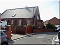
Bethel House, Dudley, formerly a Chapel, now a dwelling
Image: © Bill Henderson
Taken: 7 May 2012
0.13 miles
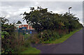
6
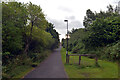
A path and cycleway between Dudley and Annitsford
Image: © habiloid
Taken: 8 Aug 2021
0.18 miles
7
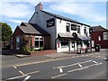
The Clayton Arms, Dudley
A pub on Northern Terrace in Dudley.
Image: © Graham Robson
Taken: 25 May 2020
0.18 miles
8
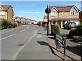
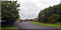
Meadowbank, Dudley
A residential estate on the northern side of Dudley.
Image: © Graham Robson
Taken: 25 May 2020
0.18 miles
9
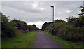
A path and cycleway between Dudley and Annitsford
Image: © habiloid
Taken: 8 Aug 2021
0.19 miles