IMAGES TAKEN NEAR TO
Green Crescent, CRAMLINGTON, NE23 7JS
Introduction
This page details the photographs taken nearby to Green Crescent, NE23 7JS by members of the Geograph project.
The Geograph project started in 2005 with the aim of publishing, organising and preserving representative images for every square kilometre of Great Britain, Ireland and the Isle of Man.

There are currently over 7.5m images from over14,400 individuals and you can help contribute to the project by visiting https://www.geograph.org.uk
Image Map
Images are licensed for reuse under creativecommons.org/licenses/by-sa/2.0
Notes
- Clicking on the map will re-center to the selected point.
- The higher the marker number, the further away the image location is from the centre of the postcode.
Image Listing (6 Images Found)
Images are licensed for reuse under creativecommons.org/licenses/by-sa/2.0
Image
Details
Distance
3
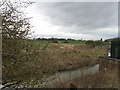
View from a Newcastle-Edinburgh train - farmland near Seaton Burn
Image: © Nigel Thompson
Taken: 11 May 2016
0.14 miles
4
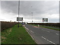
Lane to High Barnes
The rough lane leading to the farm steading and houses at High Barnes from Dudley Lane.
Image: © Graham Robson
Taken: 8 Oct 2017
0.17 miles
5
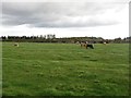
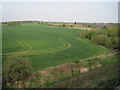
Grazing cattle at High Barnes
A group of cattle grazing the grass field adjacent to the farm yard at High Barnes.
Image: © Graham Robson
Taken: 8 Oct 2017
0.23 miles
6
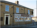
The Dudley Hotel
In the mining village of Dudley, North Tyneside
Image: © Chris Tweedy
Taken: 17 Feb 2003
0.24 miles