IMAGES TAKEN NEAR TO
The Beehive, Pit Lane, CRAMLINGTON, NE23 7FD
Introduction
This page details the photographs taken nearby to The Beehive, Pit Lane, NE23 7FD by members of the Geograph project.
The Geograph project started in 2005 with the aim of publishing, organising and preserving representative images for every square kilometre of Great Britain, Ireland and the Isle of Man.

There are currently over 7.5m images from over14,400 individuals and you can help contribute to the project by visiting https://www.geograph.org.uk
Image Map (Loading...)


Getting Data...Please wait
Leaflet Map data © OpenStreetMap
Images are licensed for reuse under creativecommons.org/licenses/by-sa/2.0
Notes
- Clicking on the map will re-center to the selected point.
- The higher the marker number, the further away the image location is from the centre of the postcode.
Image Listing (29 Images Found)
Images are licensed for reuse under creativecommons.org/licenses/by-sa/2.0
Image
Details
Distance
1
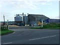
Grain Store
Drying and storing grain in Seghill
Image: © Christine Westerback
Taken: 10 Aug 2005
0.03 miles
2
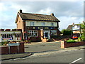
The Blake Arms
Only pub in the village of Seghill
Image: © Christine Westerback
Taken: 10 Aug 2005
0.03 miles
3
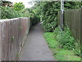
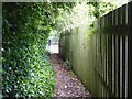
Public Bridleway Near Front Street, Seghill
This public bridleway, which follows the course of the old Cramlington Waggonway (Dudley Branch), begins on Front Street https://www.geograph.org.uk/photo/6531298, and culminates on Station Road. Whilst it is a useful link for walkers and cyclist, it is a rather unusual route for horse riders. For a selection of detailed free to download walking routes in the area visit www.northtynesidewalks.co.uk
Image: © Geoff Holland
Taken: 7 Jul 2020
0.04 miles
4
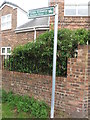
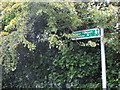
Sign, Front Street, Seghill
This public bridleway sign indicates the route, through a narrow passageway, to Station Road, Seghill. It follows the course of the old Cramlington Waggonway (Dudley Branch) a route which enabled Dudley Colliery to transport its coal down to the River Tyne. For a selection of detailed free to download walking routes in the area visit www.northtynesidewalks.co.uk
Image: © Geoff Holland
Taken: 7 Jul 2020
0.07 miles
5
Seghill end of the footpath from Cramlington
This footpath follows the line of the old West Cramlington Waggonway which ran from Klondyke to Seghill.
Image: © Oliver Dixon
Taken: 20 Jul 2020
0.08 miles
6
Sign, Front Street, Seghill
This public footpath sign indicates the way to Klondyke, a route which follows the course of the old West Cramlington Waggonway and crosses the Seaton Burn, via a set of stepping stones, some 100 metres from this point. For a selection of detailed free to download walking routes in the area visit www.northtynesidewalks.co.uk
Image: © Geoff Holland
Taken: 7 Jul 2020
0.08 miles
7
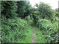
Public Footpath Near Front Street, Seghill
This public footpath, which links Seghill and Klondyke, follows the course of the old West Cramlington Waggonway and, in less than 100 metres from here, crosses the Seaton Burn via a set of stepping stones. For a selection of detailed free to download walking routes in the area visit www.northtynesidewalks.co.uk
Image: © Geoff Holland
Taken: 7 Jul 2020
0.09 miles
8
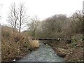
The Seaton Burn
Looking downstream along the Seaton Burn from the centre a line of stepping stones across the river.
Image: © Graham Robson
Taken: 13 Jan 2018
0.11 miles
9
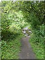
Stepping stones over the Seaton Burn
This footpath follows the line of the old West Cramlington Waggonway which ran from Klondyke to Seghill. The path is narrow and enclosed by high hedgerows on either side. It drops suddenly to cross Seaton Burn by stepping stones. The slope on the far (southern) side is steep and quite hazardous.
Image: © Oliver Dixon
Taken: 20 Jul 2020
0.11 miles
10
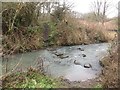
Stepping stones across the Seaton Burn
A set of stepping stones in a line across the Seaton Burn. The stones are on the route of a public footpath.
Image: © Graham Robson
Taken: 13 Jan 2018
0.11 miles