IMAGES TAKEN NEAR TO
Burradon Road, CRAMLINGTON, NE23 7BB
Introduction
This page details the photographs taken nearby to Burradon Road, NE23 7BB by members of the Geograph project.
The Geograph project started in 2005 with the aim of publishing, organising and preserving representative images for every square kilometre of Great Britain, Ireland and the Isle of Man.

There are currently over 7.5m images from over14,400 individuals and you can help contribute to the project by visiting https://www.geograph.org.uk
Image Map (Loading...)


Getting Data...Please wait
Leaflet Map data © OpenStreetMap
Images are licensed for reuse under creativecommons.org/licenses/by-sa/2.0
Notes
- Clicking on the map will re-center to the selected point.
- The higher the marker number, the further away the image location is from the centre of the postcode.
Image Listing (36 Images Found)
Images are licensed for reuse under creativecommons.org/licenses/by-sa/2.0
Image
Details
Distance
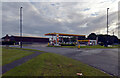
1
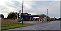
Petrol station, Front Street (B1505), Annitsford
Image: © habiloid
Taken: 7 Aug 2021
0.02 miles
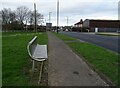
2
Bridge Cottages seen from Front Street (B1505), Annitsford
Image: © habiloid
Taken: 7 Aug 2021
0.05 miles
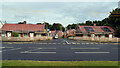
5
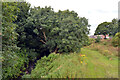
Seaton Burn seen from Front Street, Annitsford
Image: © habiloid
Taken: 7 Aug 2021
0.07 miles
8
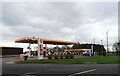
Shell service station, Annitsford
Petrol 142.9p.
Diesel 151.9p.
Image: © JThomas
Taken: 13 Feb 2024
0.09 miles
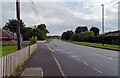
9
Petrol station, Front Street (B1505), Annitsford
Image: © habiloid
Taken: 7 Aug 2021
0.09 miles
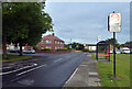
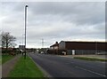
10
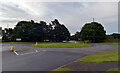
Roundabout at the junction of Front Street (B1505) and the B1321, Annitsford
Image: © habiloid
Taken: 7 Aug 2021
0.11 miles