IMAGES TAKEN NEAR TO
Grenville Court, Megstone Avenue, CRAMLINGTON, NE23 6UJ
Introduction
This page details the photographs taken nearby to Grenville Court, Megstone Avenue, NE23 6UJ by members of the Geograph project.
The Geograph project started in 2005 with the aim of publishing, organising and preserving representative images for every square kilometre of Great Britain, Ireland and the Isle of Man.

There are currently over 7.5m images from over14,400 individuals and you can help contribute to the project by visiting https://www.geograph.org.uk
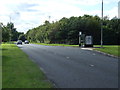
Image Map (Loading...)


Getting Data...Please wait
Leaflet Map data © OpenStreetMap
Images are licensed for reuse under creativecommons.org/licenses/by-sa/2.0
Notes
- Clicking on the map will re-center to the selected point.
- The higher the marker number, the further away the image location is from the centre of the postcode.
Image Listing (5 Images Found)
Images are licensed for reuse under creativecommons.org/licenses/by-sa/2.0
Image
Details
Distance
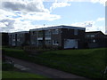
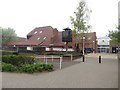
3
Cramlington police station
The police station is located in the town centre close to the large Manor Walks shopping centre.
Image: © Graham Robson
Taken: 15 May 2016
0.20 miles
4
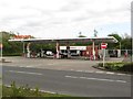
Sainsbury's petrol station, Cramlington
The fuel filling station is located some distance from the main supermarket which is on the northern side of the Manor Walks shopping centre, whilst the garage is on the southern side of the centre.
Image: © Graham Robson
Taken: 15 May 2016
0.23 miles
5
Phoenix pub, Cramlington
A public house beside one of the entrances to the Manor Walks shopping centre in Cramlington.
Image: © Graham Robson
Taken: 15 May 2016
0.24 miles