IMAGES TAKEN NEAR TO
Glencoe Avenue, CRAMLINGTON, NE23 6EH
Introduction
This page details the photographs taken nearby to Glencoe Avenue, NE23 6EH by members of the Geograph project.
The Geograph project started in 2005 with the aim of publishing, organising and preserving representative images for every square kilometre of Great Britain, Ireland and the Isle of Man.

There are currently over 7.5m images from over14,400 individuals and you can help contribute to the project by visiting https://www.geograph.org.uk
Image Map
Images are licensed for reuse under creativecommons.org/licenses/by-sa/2.0
Notes
- Clicking on the map will re-center to the selected point.
- The higher the marker number, the further away the image location is from the centre of the postcode.
Image Listing (6 Images Found)
Images are licensed for reuse under creativecommons.org/licenses/by-sa/2.0
Image
Details
Distance
1
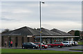
Shops and Post Office
Glenluce Drive, Southfield, Cramlington
Image: © Chris Tweedy
Taken: 14 Jan 2006
0.16 miles
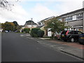
3
Terraced houses, Grassington Drive, Cramlington
A terrace of houses on Grassington Drive in Cramlington.
Image: © Graham Robson
Taken: 8 Oct 2017
0.19 miles
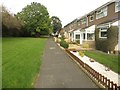
4
Path, Southfield Lea
Cramlington, between a school with its playing field and a residential area.
Image: © Richard Webb
Taken: 17 Aug 2019
0.22 miles
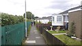
5

Fierce Sky
Looking south on a May evening. Taken from Loxton Square, Cramlington
Image: © Chris Trew
Taken: 18 May 2009
0.23 miles
6
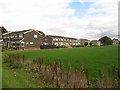
Houses, Grindon Close, Cramlington
Terraced houses in Cramlington.
Image: © Graham Robson
Taken: 8 Oct 2017
0.25 miles